
About 100 million yearsd before creationism's god decided to create a small flat planet with a dome over it to keep the water about its sky out, there were dinosaurs living in what is now northern Alaska. The problem for creationists is that the people who wrote their favourite creation myths were ignorant both of dinosaurs and Alaska so had no idea their tales needed to include something about them, which is why everything they wrote about either happened within a day or two's walk if the Canaanite Hills or were plagiarized from nearby cultures.
Now a team of paleontologists and archaeologists have discovered fossilised dinosaur footprints and the remains of plants in the Nanushuk Formation that show the climate there was warmer and wetter than today, at a time when species were migrating over the landbridge between Siberia in Asia and North America.
Unlike the Paluxy hoax, which had creationists fooled for the best part of a decade, there were no human footprints (hand-carved or otherwise) associated with these dinosaur tracks.
Because creationists will try to falsify the aging of the Nanshuk Formation, claiming the method must have been flawed to such an extent that if made 10,000 years or less look like 100 million years, here is actually how the dating was done - it’s; those dreaded zircons in volcanic deposits again, plus stratigraphy based on index fossils found in rocks of known age:
Do you have any information on the Nanushuk Formation in northern Alaska and how its age was estimated? The Nanushuk Formation is a geological formation located in northern Alaska, particularly in the North Slope region. It is primarily composed of sandstone, siltstone, and shale, and it contains significant oil and gas reserves. The formation is of great interest to geologists and petroleum geologists due to its hydrocarbon potential.The team, led by Dr. Anthony R. Fiorillo of the New Mexico Museum of Natural History & Science, Albuquerque, USA and including Professor Paul McCarthy of University of Alaska Fairbanks (UAF) College of Natural Science and Mathematics, have published their findings open access in the journal Geosciences. It is explained in a UAF news item:
The age of the Nanushuk Formation has been estimated through various methods, including biostratigraphy and radiometric dating of volcanic ash layers within the formation. Biostratigraphy involves the study of fossil assemblages found within the rocks to determine their relative ages. By comparing the fossils present in the Nanushuk Formation to those found in other formations with well-established ages, geologists can infer the approximate age of the Nanushuk Formation.
Additionally, radiometric dating techniques, such as radiocarbon dating or uranium-lead dating, can be used to determine the absolute ages of specific minerals or volcanic ash layers within the formation. These methods rely on the decay of radioactive isotopes within the rocks to estimate the time since their formation.
Through a combination of these techniques, geologists have estimated that the Nanushuk Formation was deposited during the Late Cretaceous period, approximately 70 to 80 million years ago. However, the precise age estimates may vary depending on the specific location within the formation and the methods used for dating.
A large find of dinosaur tracks and fossilized plants and tree stumps in far northwestern Alaska provides new information about the climate and movement of animals near the time when they began traveling between the Asian and North American continents roughly 100 million years ago. A map shows locations of dinosaur tracks and fossilized tree trunks and other plant life found along the Kukpowruk River.Image: Anthony Fiorillo
 The Kukpowruk River flows through tundra in northwest Alaska. Fieldwork for the dinosaur study centered on Coke Basin, a circular geologic feature along the river, about 60 miles south of Point Lay and 20 miles inland from the Chukchi Sea coast.Photo: Anthony Fiorillo
 A fossilized standing tree trunk approximately 2 feet in diameter is rooted in floodplain mudstone and sandstone in the Nanushuk Formation in northwest Alaska.Photo: Paul McCarthy
 Large carbonaceous root traces lace splay sandstone in the Nanushuk Formation in northwest Alaska.Photo: Paul McCarthy
 Anthony Fiorillo, left, and Paul McCarthy hold an Explorers Club banner during their Alaska research.Photo: Antony Fiorillo
The findings by an international team of scientists led by paleontologist Anthony Fiorillo were published Jan. 30 in the journal Geosciences. Fiorillo researched in Alaska while at Southern Methodist University. He is now executive director of the New Mexico Museum of Natural History and Science.
University of Alaska Fairbanks geology professor Paul McCarthy, with the UAF Geophysical Institute and UAF College of Natural Science and Mathematics, was a leading contributor to the research. He and UAF graduate student Eric Orphys are among the eight co-authors.
Fiorillo and McCarthy are longtime collaborators.
Fiorillo said the additional age is notable.We've had projects for the last 20 years in Alaska trying to integrate sedimentology, dinosaur paleontology and the paleoclimate indicators. We’ve done work in three other formations — in Denali, on the North Slope and in Southwest Alaska — and they're about 70 million years old. This new one is in a formation that's about 90 to 100 million years old.
Professor Paul McCarthy, co-corresponding author
College of Natural Science and Mathematics
University of Alaska Fairbanks, Fairbanks, Alaska, USA.
Research into the paleoclimate can help scientists understand the warming world of today, the authors write.What interested us about looking at rocks of this age is this is roughly the time that people think of as the beginning of the Bering Land Bridge — the connection between Asia and North America. We want to know who was using it, how they were using it and what the conditions were like.
Dr. Anthony R. Fiorillo, lead author
New Mexico Museum of Natural History & Science,
Albuquerque, NM, USA
A rich find of evidenceThe mid-Cretaceous was the hottest point in the Cretaceous. The Nanushuk Formation gives us a snapshot of what a high-latitude ecosystem looks like on a warmer Earth.
Professor Paul McCarthy.
The Nanushuk Formation is an outcropped layer of sedimentary rock 800 to 5,000 feet thick across the central and western North Slope. It dates to roughly 94 million to 113 million years ago in the mid-Cretaceous Period and about when the Bering Land Bridge began.
The fieldwork occurred in 2015-2017 and centered on Coke Basin, a circular geologic feature of the Nanushuk Formation. The basin is in the DeLong Mountains foothills along the Kukpowruk River, about 60 miles south of Point Lay and 20 miles inland from the Chukchi Sea.
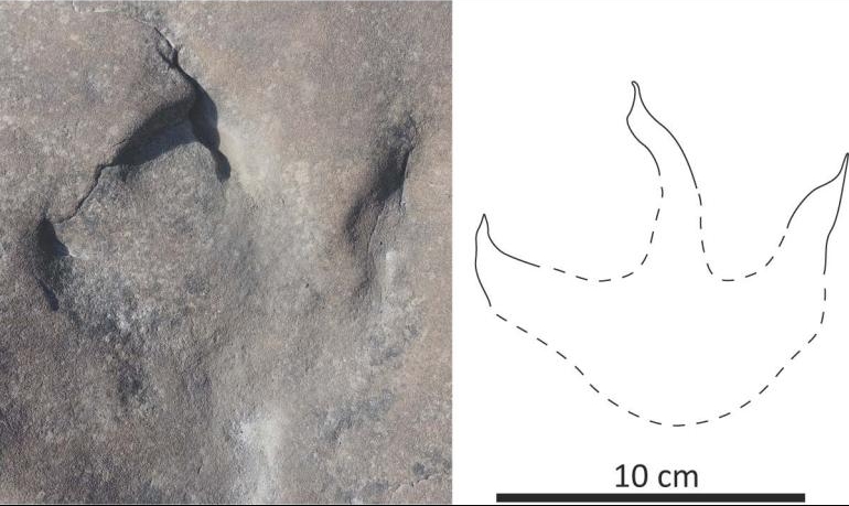
In the area, Fiorillo and McCarthy found approximately 75 fossil tracks and other indicators attributed to dinosaurs living in a riverine or delta setting.
They found numerous fossilized tree stumps, some 2 feet in diameter.This place was just crazy rich with dinosaur footprints. [One site stands out] We were at a spot where we eventually realized that for at least 400 yards we were walking on an ancient landscape. On that landscape we found large upright trees with little trees in between and leaves on the ground. We had tracks on the ground and fossilized feces. It was just like we were walking through the woods of millions of years ago.
Dr. Anthony R. Fiorillo.
The Nanushuk Formation encompasses rock of marine and non-marine characteristics and composition, but the authors’ research focuses primarily on the non-marine sediments exposed along the upper Kukpowruk River.
One of the things we did in our paper was look at the relative frequencies of the different kinds of dinosaurs. What was interesting to us was that the bipedal plant eaters were clearly the most abundant. One of the things that was interesting is the relative frequency of bird tracks.
Dr. Anthony R. Fiorillo
Two-legged plant eaters accounted for 59% of the total tracks discovered. Four-legged plant eaters accounted for 17%, with birds accounting for 15% and non-avian, mostly carnivorous, bipedal dinosaurs at 9%.
The authors point out that nearly half of North America’s shorebirds breed in the warm months of today’s Arctic. They suggest that the high number of fossil bird tracks along the Kukpowruk River indicates the warm paleoclimate was a similar driver for Cretaceous Period birds.
A wet and warm place
Carbon isotope analysis of wood samples led to a determination that the region received about 70 inches of precipitation annually. This record of increased precipitation during the mid-Cretaceous provides new data that supports global precipitation patterns associated with the Cretaceous Thermal Maximum, the authors write.
The Cretaceous Thermal Maximum was a long-term trend approximately 90 million years ago in which average global temperatures were significantly higher than those of today.
The temperature was much warmer than it is today, and what’s possibly more interesting is that it rained a lot. The samples we analyzed indicate it was roughly equivalent to modern-day Miami. That’s pretty substantial.
Dr. Anthony R. Fiorillo
Of note is that the Alaska site investigated by Fiorillo and McCarthy was about 10 to 15 degrees latitude farther north in the mid-Cretaceous than it is today.
McCarthy’s role as a fossil soils expert was to analyze old rocks and sediments to interpret the type of environment that existed at the time.
Fiorillo said the site indicates there’s much more work to be done.We can say here's a river channel, here's a flood deposit, here's a levee, here's the floodplain, here's a swamp. And so, if we're able to find tracks in that section, then you can sometimes say that a group of dinosaurs seems to have really liked being here as opposed to there.
This puts a new dot on the map and tells us there's a lot here, and it fits into the bigger picture. The big picture is we're trying to get better resolution on what life was like in the high latitudes back at the time the dinosaurs were roaming around.
Dr. Anthony R. Fiorillo


More technical data is in the team's open access paper in Geosciences
. In addition, there is a section devoted to radiometric dating, which, to the annoyance of creationists no doubt, included Uranium-Lead (U-Pb) dating of zircons. The team used two techniques termed LA-ICP-MS and CA-ID-TIMS:
In the context of U-Pb zircon dating, what do the terms, LA-ICP-MS and CA-ID-TIMS stand for and what are they? In the context of U-Pb zircon dating, LA-ICP-MS and CA-ID-TIMS are two different techniques used to analyze zircon crystals for age determination.Both LA-ICP-MS and CA-ID-TIMS are widely used in geochronology to determine the ages of zircon crystals and other minerals. They offer complementary advantages and are often used in conjunction to obtain robust age constraints for geological events.
- LA-ICP-MS:
In LA-ICP-MS, a laser beam is used to ablate small amounts of material from the surface of a zircon crystal. The ablated material is then transported into an inductively coupled plasma (ICP), where it is ionized. The resulting ions are then analyzed using a mass spectrometer (MS). By measuring the isotopic ratios of uranium and lead in the zircon crystal, geologists can determine its age.
- LA stands for Laser Ablation.
- ICP-MS stands for Inductively Coupled Plasma Mass Spectrometry.
- CA-ID-TIMS:
In CA-ID-TIMS, the zircon crystals undergo a chemical abrasion process to remove the outer layers that may have experienced lead loss or contamination. This step ensures that the zircon sample being analyzed is as pristine as possible. After chemical abrasion, the zircon crystals are dissolved, and the uranium and lead isotopes are separated and purified. The isotopic ratios are then measured using a thermal ionization mass spectrometer (TIMS). This technique provides precise and accurate age determinations, particularly for older zircon crystals.
- CA stands for Chemical Abrasion.
- ID-TIMS stands for Isotope Dilution Thermal Ionization Mass Spectrometry.
AbstractSo, conclusive evidence there then that there were dinosaurs living in a warm wet environment in what is now northern Alaska about 100 million years before, according to their favourite book of origin myths, the Bible, there was an Earth for them to live on.
The Nanushuk Formation (Albian–Cenomanian) crops out over much of the central and western North Slope of Alaska, varying from ≈1500 to ≈250 m thick from west to northeast. The Nanushuk Formation records an inter-tonguing succession of marine and nonmarine conglomerate, sandstone, mudstone, and coal. These rock units comprise the Kukpowruk and Corwin formations of the former Nanushuk Group, respectively. Work presented here is centered in the foothills of the DeLong Mountains along the Kukpowruk River, from an area west of Igloo Mountain in the Coke Basin to the Barabara Syncline, approximately 80 km to the north. A radiometric date recovered from a tuff in our study area suggests a Cenomanian age for at least some of these rocks. Outcrops along the Kukpowruk River contain a well-preserved fossil flora previously recovered from marine, marginal marine, and terrestrial sediments. Our own work focuses on detailed measured sections of terrestrial rocks, interpretation of sedimentary facies and facies associations, and documentation of fossil vertebrates. Eight facies associations are identified in the study area that together are interpreted to represent meandering fluvial and upper delta plain environments. Plant fossils are common and include standing tree trunks up to 58 cm in diameter at some locations. Approximately 75 newly discovered tracksites, and a heretofore unknown, rich fossil vertebrate ichnofauna, are present. The ichnofaunal assemblage includes evidence of small and large theropod dinosaurs (including birds) and bipedal and quadrupedal ornithischian dinosaurs. Approximately 15% of the dinosaur ichnofauna record is represented by fossil bird tracks. Wood fragments from the Nanushuk Formation were analyzed for their carbon isotopic composition to relate δ13C to mean annual precipitation. Samples averaged −26.4‰ VPDB, suggesting an average MAP of 1412 mm/year. This record of increased precipitation in the Nanushuk Fm. during the mid-Cretaceous provides new data that supports global precipitation patterns associated with the Cretaceous Thermal Maximum. This work provides an important framework for much-needed further paleoecological and paleoclimatic analyses into greenhouse conditions in the terrestrial Cretaceous Arctic during this important window in time.
1. Introduction
It is a truism that the pace of human-caused changes to global climate is increasingly overwhelming ecosystems that have, in general, been relatively stable over several thousands of years. As the world’s human population continues to explode in size at the same time as rapid climate change, it is forcing a reshaping of conservation paradigms that now include looking to the past for guidance on crucial aspects of ecosystems and their health [1]. The prevailing conservation paradigm has been to hold ecosystems to a now appreciated unrealistic idealized model of stasis. But now it is becoming clear that new approaches using historical as well as novel landscapes provide insights into key issues such as drivers of biodiversity, fundamental processes within ecosystems, and the interplay between biota and climate [2,3,4]. Sedimentary rocks from the Late Cretaceous Arctic and sub-Arctic present an opportunity to assess ecosystems that existed during an extreme planetary greenhouse condition.
The mid to Late Cretaceous of Alaska represents one of these time periods with terrestrial Cretaceous deposits ranging from the Albian to the Maastrichtian. While much work has been advanced for the Late Cretaceous Polar Arctic (Prince Creek Formation), detailed reconstruction of the mid-Cretaceous Nanushuk Formation still requires a comprehensive and quantitative approach. The Albian–Cenomanian of Alaska was arguably warmer than the Late Cretaceous Polar Arctic [5,6]. More broadly, the mid-Cretaceous was also a period of global environmental and evolutionary change that included rising sea levels, diversification of flowering plants, and vertebrate faunal diversification and turnover [7,8,9,10].
The Albian–Cenomanian time was the earliest episode of faunal exchange between Beringia and Asia, e.g., [11]. This route between the North American and Asian continents has repeatedly been key to the dispersal of organisms starting during the time represented by the Nanushuk Formation up to the more recent Pleistocene faunal exchanges. While the Nanushuk Formation is prominent across all of northern Alaska, this study focuses on exposures of the unit along the Kukpowruk River in far northwestern Alaska (Figure 1). Here, we build on the detailed earlier paleobotanical survey work by Spicer and Herman [12] and provide new sedimentological, paleontological, and paleoclimatological data for this region. While their seminal work [12] provided needed insights into floral communities ranging from marsh/heath communities to forested river margin communities found along the Kukpowruk River, their study did not provide information on fossil vertebrates and paleoclimate, with only limited sedimentological detail. As such, this study takes the first major steps to improve our understanding of this critical window in deep time.
2. Geologic Framework Figure 1. (A) Map of Alaska with a star showing location of study area. (B) Map of Kukpowruk River showing locations of fossil vertebrate tracksites (designated by combination of numbers and letters) in this study, and fossil plant sites (designated by only numbers) from study by Spicer and Herman [12]. (C–E) More detailed maps of areas of high concentration of fossil footprint sites.
The Nanushuk Fm. and coeval upper Torok Fm. fill the western part of a large, east–west trending, peripheral foreland basin across the west-central North Slope of Alaska. The basin is bounded to the south by the Brooks Range fold and thrust belt [13]. The fold and thrust belt comprises a succession of sedimentary rocks thrust northward that are partly contemporaneous with rifting on the northern flank [13,14]. The Colville foreland basin formed due to the load imposed by thrust faulted allochthons within the growing Cretaceous Brooks Range, followed by sediment deposition eroded from them. Orogen-wide uplift and erosion between 135–95 Ma resulted in the deposition of clastic sediments to the north and northeast, including early Albian to Cenomanian fluvial–deltaic strata of the Nanushuk Fm. [15,16].
The Nanushuk Fm. and upper Torok Fm. are present in the northern foothills belt and in the subsurface of the North Slope coastal plain (Figure 2). The Nanushuk Fm. is a succession of inter-tonguing marine and nonmarine rocks interpreted as marine shelf, delta plain, strandplain, fluvial, and alluvial overbank deposits [14,15,16,17,18,19,20,21,22,23]. Mull et al. [24] revised the stratigraphy of the Albian–Cenomanian Nanushuk Group, which included the marine Tuktu, Grandstand, and Ninuluk formations, the predominantly nonmarine Chandler and Corwin formations, and the marine–nonmarine Kukpowruk Formation. Mull et al. [24] downgraded the Nanushuk Group to formation status, incorporating all six formations of the former Nanushuk Group. Thickness estimates for the Nanushuk Fm. range from 2750 m along the Chukchi Sea coast in the west [21] to a zero edge ≈75 km east of Umiat, and in the vicinity of the modern Colville delta. The Nanushuk Fm. crops out in the northern Brooks Range foothills belt and coastal plain, comprising a lower dominantly marine unit of inter-tonguing shallow-marine shale, siltstone, and sandstone (Tuktu and Grandstand formations of former usage), that grades to the north to east-northeast into outer-shelf, slope, basinal shale, and minor sandstone of the upper Torok Fm. [15,16]. This grades up-section into primarily nonmarine mudstone, coal, sandstone, and conglomerate (Chandler Formation of former usage). These nonmarine rocks intertongue with rocks representing coastal facies within the Nanushuk Fm. [15,16]. Overall, the Nanushuk Fm. comprises a thick regressive package, interrupted many times by marine flooding that resulted from delta lobe shifting and abandonment.
Throughout the western North Slope of Alaska, an angular unconformity bounds the Nanushuk Fm., separating nonmarine Cretaceous rocks from overlying Pleistocene sediments. In the central North Slope and the subsurface of the eastern National Petroleum Reserve-Alaska (NPRA), Cenomanian intertonguing fluvial sandstone, paludal mudstone and coal, and shallow-marine sandstone and silty shale overlies dominantly nonmarine Nanushuk rocks [15,25]. These 350 m thick intertonguing nonmarine and marine rocks were included in the Niakogon Tongue (Chandler Formation) and Ninuluk Formation of former usage, and now part of the Nanushuk Formation, and record a change from regression to regional transgression [25]. At outcrop and in the subsurface where the lower contact of the Nanushuk with the Seabee Fm. is present, the Seabee typically consists of a thin, basal transgressive lag of fine- to medium-grained sandstone a few cm to dm thick that grades into thin-bedded fine- to very fine-grained sandstone a few meters thick that is overlain by bentonite-rich mudstone. Alternatively, the basal lag may be abruptly overlain solely by bentonite-rich mudstone. Figure 2. Stratigraphic nomenclature for Cretaceous and Paleocene rock units of the North Slope of Alaska.
Alhbrandt et al. [21] recognized two major delta systems in the Nanushuk Fm.; the Corwin Delta, on the western side of the basin, and the Umiat Delta on the eastern side. Both the Corwin and Umiat Deltas are not individual deltas, instead representing thick deltaic depocenters, or complexes, comprising the deposition of many individual delta lobes. Fisher et al. [18] suggested that the eastern delta was river dominated. Ahlbrandt et al. [21] and Huffman et al. [20] indicated that both delta complexes were river dominated, but they also suggested that the Umiat delta complex was affected by greater wave reworking. Recent work suggests that river- and wave-reworking of delta complexes varies temporally as well as spatially in the eastern Nanushuk Fm., with initial wave dominance followed by subsequent river influence in shallower, more wave-limited conditions created by earlier parasequence progradation and shelf construction [26].
Previous work indicates high mud and low sand contents in the Corwin delta complex [16,20,27], suggesting that the western delta complex was characterized by river-dominated delta lobes that prograded east-northeastward obliquely along the Colville basin axis [20,21,28]. In the Wainwright # 1 core to the northeast of our study area, LePain and Decker [28] documented lower and upper delta plain facies in the subsurface. Our outcrop facies analysis documents nonmarine sediments similar to their upper delta plain or alluvial plain facies. Biostratigraphic data indicates an early Albian to late Albian age for the Corwin Delta complex along the Chukchi Sea coast, which becomes younger in the east and north [19,21]. The Corwin delta complex dominated depositional patterns in the western two-thirds of the foreland basin [15] at a paleolatitude of ≈75° N [29].
3. Radiometric Data from Study Area
LA-ICP-MS U-Pb zircon geochronology allows in situ grain spatial resolution [29] and high single grain resolution throughput (usually >100 grains per sample analysis), which is required for (a) dating complex zircons, (b) detrital studies, and (c) accurately dating bentonites with a potential detrital or xenolith component. Determining crystallization/eruption or maximum deposition age “calls” from LA-ICP-MS U-Pb zircon data are complicated by potential undetermined Pb loss for young zircons (<~400 Ma), matrix mismatch, and large N analysis resulting in apparently robust populations of younger grains that are just an artifact of instrumental statistical spread [30,31,32].
CA-ID-TIMS has higher accuracy and precision and can usually mitigate the effects of potential Pb loss [33], but this whole grain technique is time intensive, resulting in fewer grains analyzed per sample (usually ~3 to 7 grains) and no in situ grain spatial resolution. Hence, there is a tradeoff between LA-ICP-MS and CA-ID-TIMS U-Pb zircon dating applications. Many labs are now screening zircon grains via large N LA-ICP-MS U-Pb analysis and then performing CA-ID-TIMS U-Pb zircon analysis on select grains [34]. This dual-technique combination, though powerful, adds significant expense and time.
Furthermore, these dual-technique studies have demonstrated that selecting the LA-ICP-MS U-Pb zircon youngest statistical population (YSP), which is the weighted mean of the youngest statistical population (2 or more grains) that produces a mean square weighted deviation (MSWD) close to 1, approximates CA-ID-TIMS U-Pb zircon results from the same sample [35,36]. A variation of this approach is the youngest mode weighted mean (YMWM), which uses the LA-ICP-MS zircon dates that define the youngest age mode from a kernel density estimate peak that consists of at least three grains that overlap at 2 sigma uncertainty with an MSWD that approximates 1 [32,34]. We use a modified version of the YSP and YMWM age determinations by utilizing an iterative approach that captures the largest population of young grains that overlap at 2 sigma uncertainty with an MSWD that approximates 1. We call this approach the largest youngest statistical population (L-YSP) and favor it, because it allows the parsing of potential young tails that may have experienced Pb loss and older detrital and/or xenolith grains [37]. The results are often like those from Tuffzirc [38], which follows a similar approach, but uses a not-explained modified 2 sigma uncertainty overlap and can capture older grains that do not approximate depositional–eruption ages.
We applied a 10% uncertainty filter to remove less precise grains with possible isotopic/analytical concerns. We use the macro-spread sheet from Herriot et al. [36] to both iteratively select grains and to calculate a weighted average age and systematic uncertainty. Based on the weighted average age of 34 out of 103 zircon grains dated, we determined an eruption age of 97.20 ± 0.53 with an MSWD of 0.98 for the bentonite sample 15-EO-8-17-2 (Figure 3).4. Sedimentology Figure 3. Plot of 206 Pb/238 Pb data that yielded an age of 97.1 Ma.
While the Nanushuk Formation encompasses marine and nonmarine facies, this paper focuses primarily on nonmarine fluvial sediments of the rock unit that are exposed along the upper Kukpowruk River (Figure 4). Plant fossils, reflecting successional, riparian, and interfluve environments (Figure 5A) [12], and upright tree trunks in situ (up to 58 cm diameter) are relatively common in nonmarine facies along the Kukpowruk River.


 Figure 4. Representative measured sections of fluvial sedimentary successions along the Kukpowruk River, NW Alaska. Legend is shown in lower right. Representative measured sections of fluvial successions along the Kukpowruk River, NW Alaska. See Figure 3 for legend. Representative measured sections of fluvial successions along the Kukpowruk River, NW Alaska. See Figure 3 for legend.
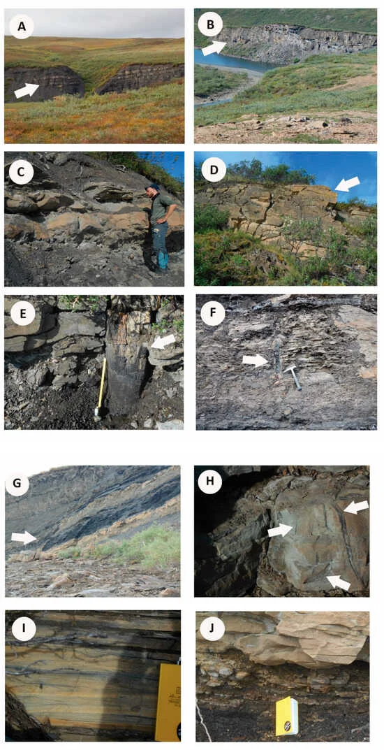 Figure 5. (A) Interbedded sandstone, siltstone, shale, and coal typical of floodplain facies. (B) Multi-story channel-fill sandstone. (C) Floodplain mudstone and sandstone with standing trees at base (not shown). (D) Trough cross-bedded channel sandstone. (E) Standing tree trunk rooted in floodplain mudstone and sandstone (max. 58 cm diameter). (F) Floodplain mudstone with standing tree (adjacent to hammer length = 33 cm). (G) Interbedded, ripple-laminated sandstone, siltstone, shale, and coal typical of a poorly drained floodplain. (H) Large carbonaceous root traces in splay sandstone. (I) Ripple cross-laminated sandstone with abundant organic fragments (coffee grounds) on forests. (J) Floodplain mudstone coarsening upward into splay and levee sandstone sheets.
Fiorillo, A.R.; McCarthy, P.J.; Shimer, G.; Suarez, M.B.; Takasaki, R.; Chinzorig, T.; Kobayashi, Y.; O’Sullivan, P.; Orphys, E.
New Dinosaur Ichnological, Sedimentological, and Geochemical Data from a Cretaceous High-Latitude Terrestrial Greenhouse Ecosystem, Nanushuk Formation, North Slope, Alaska.
Geosciences 2024, 14, 36. https://doi.org/10.3390/geosciences14020036
Copyright: © 2024 The authors.
Published by MDPI, Basel, Switzerland. Open access.
Reprinted under a Creative Commons Attribution 4.0 International license (CC BY 4.0)


Any normal people, confronted with compelling and unarguable evidence that their favourite myths are wrong, would stop believing otherwise and start to live in the real world not the fantasy the mythic cult requires them to live in.
Not creationists, however. Through a combination of self-idolatrous arrogance, hypocrisy and theophobic psychosis, they will perform any mental gymnastics needed to stick with their falsified beliefs and ignore the evidence that refutes them. The correct term for this is intellectual and scientific bankruptcy.


No comments :
Post a Comment
Obscene, threatening or obnoxious messages, preaching, abuse and spam will be removed, as will anything by known Internet trolls and stalkers, by known sock-puppet accounts and anything not connected with the post,
A claim made without evidence can be dismissed without evidence. Remember: your opinion is not an established fact unless corroborated.