

The beautiful and timeless river Nile at Luxor, cradle of civilisation, where we spend a wonderful ten days some years ago having completed a river cruise from Luxor to Aswan and been driven back to our hotel in Luxor in a high-speed convoy with military escorts - for me, the high-point of the holiday; for my partner, not so much, especially when our driver insisted on stopping in the middle of nowhere to relieve himself behind a rock, leaving us alone in the car with our guardian soldier escort fingering his sub machine gun nervously.
But the lovely old River Nile has not always flowed in its present bed. From before, during and after creationism's legendary global flood through which Egyptian society appears to have come without harm and without leaving a single record, not even a hint of sediment in the Nile floodplain, the Nile has changed its course multiple times, according to recent research by an international team of archaeologists, which included researchers from Southampton University, England.
Please tell me what you know of the history of the River Nile over the past 11,500 years. The history of the River Nile over the past 11,500 years is deeply intertwined with the development of human civilization, environmental changes, and geological events. Here’s a detailed overview:According to their discovery, the Nile has evolved over the past 11,500 years. Changes in its geography shaped the fortunes of the ancient Egyptian civilisation. For instance, a shift in its course around 4000 years ago (right in the middles of what creationists like to imagine was a global genocidal flood in which their god exterminated all life on Earth save for two (or seven, depending on the version) of each species sealed up in a floating wooden box for the best part of a year [sic]. Meanwhile, the Egyptian civilisation carried on as though nothing untoward was happening. At the end of this period, the floodplain in the vicinity of Luxor, then called Thebes, capital of the Upper Kingdom, was greatly extended, increasing the available agricultural land.The Nile's history is a testament to its enduring importance to the civilizations that have flourished along its banks. It has shaped human history and continues to be a crucial natural resource in the region.
- Early Holocene Period (circa 11,500 years ago - 5000 BCE)
- Climate and Environment During the early Holocene, the Sahara was a much wetter region due to the African Humid Period. This climatic shift led to increased rainfall in the Nile Basin, feeding the river and supporting lush vegetation and abundant wildlife.
- Human Settlement The fertile Nile Valley attracted early human settlers who practiced hunting, gathering, and early forms of agriculture. Archaeological evidence suggests that these communities relied heavily on the river for sustenance.
- Neolithic Period (circa 5000 BCE - 3000 BCE)
- Agricultural Development The gradual drying of the Sahara led to the concentration of human populations along the Nile. People began to develop more advanced agricultural techniques, such as irrigation, to harness the Nile's waters for farming.
- Cultural Evolution This period saw the rise of complex societies, with increased social stratification and the development of early forms of governance.
- Predynastic and Early Dynastic Egypt (circa 3500 BCE - 2686 BCE)
- Formation of States Small states and kingdoms began to emerge along the Nile, eventually leading to the unification of Upper and Lower Egypt. The Nile was central to the economic and political life of these early states.
- Technological Advances Advances in irrigation and agricultural techniques allowed for surplus food production, supporting population growth and urbanization.
- Ancient Egyptian Civilization (circa 2686 BCE - 30 BCE)
- Pharaonic Period The Nile was the lifeblood of ancient Egyptian civilization. It facilitated agriculture, trade, and communication. The annual flooding of the Nile deposited nutrient-rich silt on the land, ensuring fertile soils for farming.
- Construction of Monuments Major monuments, including the pyramids and temples, were constructed along the Nile. The river was also used to transport materials for these monumental projects.
- Religion and Culture The Nile had immense religious significance. It was personified as the god Hapi and was central to many myths and rituals. The river's cycles were closely tied to the Egyptian calendar and agricultural practices.
- Classical Antiquity (circa 30 BCE - 640 CE)
- Roman and Byzantine Egypt Following the fall of the Ptolemaic Kingdom, Egypt became a province of the Roman Empire. The Nile continued to be a crucial resource for grain production, which was essential to feeding Rome.
- Decline in Flooding There were fluctuations in the Nile's flooding patterns, which sometimes led to agricultural challenges and famine.
- Islamic Period and Medieval Times (circa 640 CE - 1500s CE)
- Islamic Conquest After the Islamic conquest of Egypt in the 7th century, the Nile remained central to the region's prosperity. The river supported agriculture and trade, and Cairo became a major cultural and economic hub.
- Medieval Observations Scholars and travelers documented the Nile's behavior and its importance to Egyptian society during this period.
- Early Modern Period (1500s CE - 1800s CE)
- Ottoman Rule Under Ottoman rule, the Nile continued to be a vital resource for agriculture and transportation. Efforts were made to improve irrigation systems and control the river's flow.
- European Exploration The Nile became a focus of European explorers seeking to map the river and understand its sources.
- Modern Era (1800s CE - Present)
- Colonial Influence The British occupation of Egypt in the 19th century saw major infrastructural projects, such as the construction of the Aswan Low Dam (completed in 1902), aimed at regulating the Nile's flow.
- Aswan High Dam Completed in 1970, the Aswan High Dam had a profound impact on the Nile. It allowed for better control of flooding, increased agricultural productivity, and provided hydroelectric power, but also led to ecological and cultural changes.
- Contemporary Issues Today, the Nile faces challenges such as pollution, water management conflicts among the Nile Basin countries, and the impacts of climate change. The Grand Ethiopian Renaissance Dam (GERD) is a significant modern development that has sparked debates over water rights and usage among Egypt, Sudan, and Ethiopia.
The study also suggests that the change in the Nile's course may have influenced the sighting of the temple complex at Karnak, on the edge of Luxor.
The team was led by Dr Angus Graham of Uppsala University in Sweden, and included scientists from Amsterdam and Utrecht, Netherlands; the Louvre, Paris, France; Oxford, London, Manchester, Salisbury and Southampton, UK; Egypt, and New Mexico and Michigan, USA.
They have just published their findings, open access in Nature Geoscience, and explained it in a Southampton University news release:
Researchers have explored how the River Nile evolved over the past 11,500 years and how changes in its geography could have helped shape the fortunes of ancient Egyptian civilisation.
 Percussion-corer team drilling for geological samples in a sugarcane field.Credit: Angus Graham
Research published in Nature Geoscience reveals a major shift in the Nile around four thousand years ago, after which the floodplain in the Nile Valley around Luxor greatly expanded.
The findings raise the possibility that this shift could have contributed to the success of the ancient Egyptian agricultural economy at points between the Old and New Kingdom periods. The New Kingdom was a period of unparalleled prosperity, military conquest, and cultural achievement in Ancient Egyptian history.
The expansion of the floodplain will have greatly enlarged the area of arable land in the Nile Valley near Luxor (ancient Thebes) and improved the fertility of the soil by regularly depositing fertile silts. While no specific causal links can be inferred between this shift and any contemporaneous social developments, the changes in the landscape are nonetheless an important factor that need to be considered when discussing the trajectory of Ancient Egyptian culture.
Dr Benjamin T. Pennington, co-author
Geography and Environment
University of Southampton, Southampton, UK.
The study also suggests that changes in the Nile's behaviour and landscape might have influenced settlement patterns and the location of iconic historical structures, such as Karnak temple.
The research was carried out by an international team led by Dr Angus Graham of Uppsala University in Sweden and including several archaeologists and geographers from the University of Southampton.
We drilled 81 boreholes, many by hand, across the whole Nile Valley near Luxor – a genuine first for Egypt. Using geological information contained within the cores, and dating the sediments using a technique called Optically Stimulated Luminescence we were able to piece together the evolution of the riverine landscape.
Dominic S Barker, co-author
Archaeology
University of Southampton, Southampton, UK.
The team found that between around 11,500 and four thousand years ago, the Nile experienced significant valley incision, meaning the river cut down into its bed, creating deep channels and a narrower flood plain. This may have led to more pronounced and forceful flooding.
These flood dynamics would have been in place between the Epipalaeolithic period (a time of hunter-gatherer societies) and the Old Kingdom (the ‘age of the pyramids’) and perhaps the Middle Kingdom of ancient Egypt.
The Egyptian Nile we see today looks very different from how it would have been throughout much of the last 11,500 years. For most of this time, the Nile was made up of a network of interwoven channels that frequently changed their course.
>Dr Benjamin T. Pennington.
Around 4,000 years ago, the Nile abruptly shifted and there was rapid floodplain aggradation, where the river began depositing large amounts of sediment, building up the valley floor. This created a more expansive and stable floodplain.
The river also progressively changed character during this time – from a dynamic wandering-braided system to fewer, more stable channels. The single-channel Nile we are familiar with today didn’t really establish itself until around two thousand years ago.
The researchers say the major shift in the Nile’s behaviour was likely caused by a reduction in the volume of water flowing through the river and an increase in fine sediment supply. This was driven by the aridification of the Nile basin, with the ‘Green Sahara’ of the African Humid Period transforming into the present-day hyper-arid Sahara Desert. This shift in regional climate may have further combined with changing human impacts on the land to make the soil more prone to erosion.
The new insights into the evolution of the Egyptian Nile Valley near Luxor provide essential landscape context for archaeologists and Egyptologists to reinterpret ancient sites in the region and re-consider locations of settlements in the Nile Valley.
The paper Shift away from Nile incision at Luxor ~4,000 years ago impacted ancient Egyptian landscapes is available online.

AbstractNo hint then of a global flood around 4,000 years ago, like the Bible legend claims, and a continuous history of a civilisation and a changing river Nile from before creationism's 'Creation Week', through the alleged genocidal flood and into modern times.
Although the Nile is one of the largest rivers in the world and played a central role in ancient Egyptian life, little is known about its response to climatic change during the Holocene. Here we present a framework for the evolution of the Egyptian Nile, demonstrating how climatic and environmental changes have shaped the landscape of the Egyptian Nile Valley over the past 11,500 years, including the civilization of ancient Egypt (~5,000 to 2,000 years ago). Using data from over 80 sediment cores drilled in a transect spanning the Nile Valley near Luxor, pinned in time by 48 optically stimulated luminescence ages, we reconstruct the dynamics of the Nile River during the Holocene in the vicinity of UNESCO World Heritage sites such as Karnak and Luxor temples. According to our reconstruction, valley incision occurred from the start of the record until approximately 4,000 years ago and then rapidly shifted to massive floodplain aggradation. We argue that this relatively abrupt change in the riverine landscape near Luxor from the Middle to Late Holocene was linked to a shift towards a drier regional hydroclimate around this time. Such a dramatic change in river sediment dynamics could have had local agro-economic consequences.
Main
The River Nile forms the fertile corridor that links its headwaters in equatorial Africa to its delta in the Mediterranean (Fig. 1)1. An understanding of its evolution through the Holocene is pivotal to discussions of fluvial system dynamics and ancient cultural development, which both occurred against a backdrop of major hydroclimatic change: that is, the shift from the ‘Green Sahara’ of the African Humid Period (~14.5–5.0 thousand years ago (ka))2,3,4,5 to the present hyper-arid Sahara Desert6,7. The present understanding of the Egyptian Nile’s response to climate change relies heavily on data gathered from its delta8,9, its offshore Mediterranean deep-sea fan4,10,11,12,13 and the Fayum depression14. Few studies have focused on the fluvial domain itself15,16,17, and very little is known about the Holocene development of the Egyptian Nile Valley18,19,20,21 despite its central role in ancient Egyptian history22,23. Furthermore, previous research on the Egyptian Nile is often lacking detailed chronostratigraphic and sedimentological data that make existing reconstructions highly uncertain and inconsistent22,24.To address this knowledge gap, a transect of 81 boreholes spanning the Nile Valley (~10 km wide) was drilled near Luxor (ancient Thebes) in Upper Egypt (Fig. 1). Sedimentary information from these cores (average depth ~8 m) (Supplementary Data 1) was used to study key changes in the riverine landscape, which are pinned in time by 48 optically stimulated luminescence (OSL) ages (Extended Data Figs. 1–4 and Extended Data Tables 1–4). This approach provides a unique and vital understanding of the Holocene Egyptian Nile system and its responses to climate change at a focal region of ancient Egyptian culture. Our area of investigation includes UNESCO World Heritage sites such as the Karnak and Luxor temples located east of the present Nile (Fig. 1) and the royal cult temples and necropoleis on the western desert margin—places that were both physically and mythologically connected to the fluvial landscape25,26. In addition, it is possible that the changing environment also impacted the regional agro-economy, which was of critical importance to the success of the ancient Egyptian state27,28.Fig. 1: Geomorphic map of the Nile Valley near Luxor, Egypt.Smaller black dots mark borehole locations; larger black dots mark OSL-dated core sites and are labelled with Roman numerals. a–f, Key archaeological sites: Karnak Temple complex (a), Luxor Temple (b), Medinet Habu (c), Kom el-Hettân (d), Ramesseum (e) and Valley of the Kings (f). The inset map shows the Nile Basin (dark grey) in Northeast Africa, its drainage system (blue) and the Egyptian Nile Valley (black). Methods provide more OSL dating details, and Extended Data Tables 1 and 3 provide cross references with original core-site numbering. Med., Mediterranean. Figure created using ArcGIS Pro. Credit: background World Imagery Basemap, Esri.
Our study shows how the floodplain environment changed dramatically during the Dynastic Period (~5.1–2.4 ka) (Extended Data Table 5) and how the environmental canvas on which ancient culture developed, thrived and declined was reshaped. We introduce a framework for the Egyptian Nile near Luxor, while also filling in the looming gap in hydroclimatic information that exists between upstream and downstream locations within the Nile Basin29.
Sedimentary architecture of Holocene Egyptian Nile Valley At various levels in the subsurface along our transect near Luxor, the borehole data reveal basal, sandy deposits, which are interpreted as fluvial terraces (units T1–4; Fig. 2 and Table 1). These erosional terraces are the result of long-term semi-continuous valley-wide fluvial incision and contraction during the first half of the Holocene. Subsequently, a shift occurred to a fast-aggrading Nile system during the remainder of the Holocene, whose deposits blanketed the earlier terrace morphology. Multiple channel belts (units CB1–3b) and a laterally expanding floodplain (unit FP1) are associated with this more recent phase of fluvial aggradation and valley expansion.
The oldest terrace (T1; Fig. 2 and Table 1) is dated to 9.42 ± 0.75 ka and forms the oldest present-day exposed surface at the eastern valley margin at an elevation of ~78.5 m above mean sea level. Westward, buried underneath ~1 m of younger alluvium, the top of terrace T2 lies at ~75 m and is dated to 8.85 ± 0.66 ka. Further towards the centre of the valley, the top of terrace T3, at 70–72 m, is dated to 4.54 ± 0.42 ka; a small remnant of T3 is also preserved at the West Bank’s desert edge. The youngest terrace, T4, at 66–68 m, is dated to 4.09 ± 0.31 ka and is only found on the West Bank. This terrace forms the substrate from which fluvial aggradation initiated and thus marks an important turning point in the fluvial history of the Nile Valley.Fig. 2: Sedimentary architecture of the Holocene Nile Valley near Luxor, Egypt. Figure 1 provides transect and OSL-dated core-site locations. OSL ages are shown with only one decimal for legibility; Methods and Extended Data Figs. 1–4 and Tables 1-4 provide a comprehensive account of the OSL dating. Table 1 provides sedimentary descriptions and facies interpretation of each geogenetic unit. W, west; E, east; +m.s.l., above mean sea level.
Three channel belts (CB1–3) can be distinguished in the transect (Fig. 2 and Table 1), with (the end of) their activity dated to 3.34 ± 0.27 ka (CB1), 2.81 ± 0.21 ka (CB2) and 0.11 ± 0.01 ka (CB3) respectively. CB3b comprises the present-day Nile. CB1 is 500–600 m wide and corresponds in age and geometry with a previously studied secondary river channel on the Theban West Bank26,30. CB2 measures ~1,200 m across and so may have carried the Nile’s full discharge. CB3 is ~1,800 m wide and was partially abandoned during the first half of the twentieth century31. The modern Nile belt (CB3b) is 600–750 m wide. Its channel is presently entrenched by 2–3 m, probably in response to sediment deprivation due to the construction of the Aswan High Dam in the 1960s.
Floodplain deposits (FP1; Table 1) blanket both banks, varying in thickness between 1 and 1.5 m in the east to ~9.5 m in the west (Fig. 2). Eight OSL ages at core-site VII determined floodplain sedimentation rates at ~12 mm per year around 3.4 ka (that is, New Kingdom age; Extended Data Table 5), whereas rates of the last three millennia were substantially lower at ~2 mm per year (Extended Data Fig. 5).
Hydroclimatic impact on the Nile’s evolution
Our research reveals a major shift in the Nile’s fluvial system behaviour, a turning point largely unrecognized in its phasing, time frame and mechanism in previous Nile river dynamics models22,23,29 and adds to other studies that have inferred Holocene deposition19,24,28. We found a sequence of channel entrenchment and contraction during the Early and Middle Holocene (Fig. 3a–d) that completely reverts to valley-wide fluvial aggradation around 4 ka (Figs. 3e–h and 4a), potentially coinciding with the 4.2 ka climate event32. Such system changes are usually related to a (combination of) substantial increase in sediment supply, sediment fining and/or a decrease in discharge33, forced by changes in the hydroclimate regime.The changes observed here in the Egyptian Nile’s Holocene riverine landscape near Luxor are in line with observations of their drivers (Fig. 4b–g), evidence for which is found elsewhere in the Nile Basin. From ~11.5 ka onward, wet conditions existed over northern Africa (Fig. 4d,e,l)6,7,34,35,36, due to a northern position of the Intertropical Convergence Zone4, which resulted in increased Nile discharge enlarging its erosivity and transport capacity (Fig. 4f)11,12,13,37. Wetter conditions also led to a denser vegetative cover6,7, reducing upstream sediment input (Fig. 4g)11,12,38. The observed erosion and subsequent uptake of sediment in the Nile Valley through channel incision was, therefore, probably a direct result of the wetter Early Holocene Nile Basin’s hydroclimatic regime.Fig. 3: Schematic reconstruction of the Holocene evolution of the Nile River near Luxor, Egypt. a–d, During the Early and Middle Holocene (a), Epipalaeolithic deposits were incised by ~3.5 m during the Late Epipalaeolithic (b), which were subsequently incised by 3–5 m during the Old Kingdom (c) and again during the Middle Kingdom (d) by another 2–4 m, forming the Nile Valley’s substrate, while consistently narrowing its active floodplain at each erosional step. e–g, From the New Kingdom (e) onward, fluvial aggradation and channel belt formation starts and continued during the Third Intermediate Period (f) until the mid-twentieth century (g) when upstream dam construction started to reduce sediment supply. h, Until recently, the Nile River managed to gradually build up and enlarge its floodplain, eventually spanning almost its entire valley. Egyptian cultural periods: Extended Data Table 5; ages (ka): Table 1.
Fig. 4: Synthesis of the Egyptian Nile Valley’s fluvial evolution in relation to hydroclimatic changes in the Nile Basin.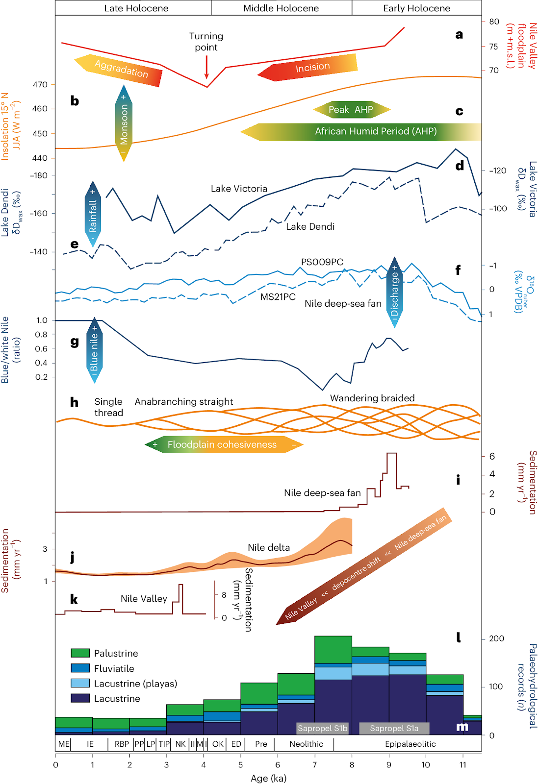 a, Nile Valley floodplain incision and aggradation levels (this study). b, Summer insolation (June, July, August (JJA)) at 15° N (ref. 48) as indicator for monsoon strength. c, Duration of the African Humid Period (AHP)3; peak AHP4. d,e, Hydrogen isotope record from leaf waxes (δDwax) as proxy for precipitation variation in the Lake Victoria basin (d)35 and the Ethiopian Highlands (Lake Dendi)36 (e). f, Globigerinoides ruber oxygen isotope as a proxy for Nile discharge recorded on its deep-sea fan. MS21PC: central deep-sea fan; PS009PC: eastern deep-sea fan12. g, Blue/white Nile provenance in deep-sea fan sediments11. h, Fluvial planform of the Nile River near Luxor (this study). i–k, Sedimentation rates (mm yr−1) for the Nile deep-sea fan11, (i), spatially averaged values for the northern Nile Delta45 (j) and average rates for the Nile Valley near Luxor (k) (this study; Extended Data Fig. 5). l, North African (10–28° N) palaeohydrological lake records as proxy for humidification and aridification of the Sahara and Sahel regions34. m, Eastern Mediterranean Sapropel S1a/b49. Egyptian cultural periods: Extended Data Table 5.
Conversely, rapid aggradation and formation of CB1–3b in the Nile Valley from ~4 ka onward is thought to have been triggered by a diminishing discharge (and hence erosion capacity) and an increase in (fine) sediment supply11,12,17,39. The driving factor behind this increase was the progressive aridification of the Nile Basin, especially between 5 and 6 ka (Fig. 4c,l)3,6,34,40, which, potentially in combination with changing human impact on the hinterland41,42,43, made soils increasingly prone to erosion44.
This major shift in the Nile’s system led to progressive changes in the fluvial planform of the Egyptian Nile near Luxor (Fig. 4h), from a dynamic wandering-braided system (T1–4) during its incisive phase (~11.5–4 ka), to less-dynamic anabranching straight channels (CB1–2 and CB3’s predecessor) during its transition (~4–2 ka) (Fig. 3e,f) and the present single-thread system (CB3(b)) during its most recent phase (~2 ka–present) (Fig. 3g,h). The large input of fine sediment promoted cohesive bank and floodplain formation, enhancing their erosion-resistance and progressively securing the low-gradient channels (CB1–3) in their position. Limited migration facilitated the build-up of natural levees and increased the elevation difference with the backswamp areas. This led to rearrangement of the Egyptian Nile’s channel configuration in an avulsive manner following levee breaches during high flood stages21,26, rather than gradual lateral migration as has been previously suggested for the presumed meandering Egyptian Nile system22,23.
On a supraregional scale, these changing hydroclimatic conditions led to increased fluvial dynamics, and in combination with sea-level rise in the Mediterranean8,9, resulted in the onlap of alluvium and creation of floodplains in downstream regions from 7–8 ka ago. Over time, the Nile’s depocentres shifted progressively upstream, from the Nile’s deep-sea fan all the way up to Upper Egypt, implying diachronous onsets in aggradation (Fig. 4i–k) and basically backfilling its valley. The increase in sediment supply, in combination with a reduction in discharge, and helped by a deceleration of Late Holocene sea-level rise, will have accelerated the upstream movement of the location where the river started to aggrade.
Before ~8 ka, most of the sedimentation occurred on the western deep-sea fan, with records showing accumulation rates of >1 mm per year (Fig. 4i)10,11. From ~8–5.5 ka, sedimentation on the deep-sea fan notably slowed down, whereas the Nile Delta started to build up at rates of >2 mm per year (Fig. 4j)9. Here the erosion upstream in the Nile Valley, together with rising Holocene sea levels, led to enhanced aggradation9,45. From ~5.5–4 ka, sedimentation on the Nile’s deep-sea fan remained low, whereas deposition in the delta dwindled to 0.5–1.5 mm per year (Fig. 4i,j)9. Instead, sedimentation increased in the downstream end of the Nile Valley, where aggradation started around 7.7 ka ago20. In Middle Egypt, aggradation started before ~4.5 ka (ref. 21), earlier than the onset of aggradation near Luxor. From 4 to 3 ka, rapid floodplain aggradation in the still-confined valley setting peaked with sedimentation rates of ~12 mm per year in the Nile Valley near Luxor (Fig. 4k), while remaining low in the delta. After ~3 ka and until the present, sedimentation in the Nile Valley progressively slowed to ~2 mm per year. Further upstream beyond Aswan, no such alluvial onlap is found as base levels were controlled by the Nile cataracts. This also hampers a direct comparison of fluvial dynamics of the Egyptian Nile and the Sudanese Desert Nile16.
The decline in floodplain sedimentation in the Nile Valley near Luxor is accompanied by regional Calcisol formation (Table 1), signalling a temporary stagnation of Nilotic overbank deposition during ~3.1–2.7 ka that was previously associated with a period of lower flow during the late New Kingdom to Third Intermediate Period (Extended Data Table 5)26,29,30. Yet, our insights indicate that this cannot be fully attributed to reduced flow conditions of the Nile, as the reduced accumulation rates also reflect substantial lateral expansion of the Nile’s floodplain, which doubled in width around 2.8 ka (Fig. 3f) as pre-existing high terrace levels were re-submerged by ongoing aggradation.
Impacts on the ancient Egyptian landscape
Variations in ancient and recent Nile floods are often discussed in terms of their impacts on Egyptian society22,29,46. The Early and Middle Holocene valley entrenchment with channel-bed incision and floodplain narrowing as found in our research (~11.5–4 ka) will have resulted in lower absolute flood levels during this time, assuming no changes in peak discharge. However, this same narrower floodplain will also have made floods more turbulent with a higher amplitude, as water was funnelled through a narrower valley corridor (Fig. 3c,d). These flood dynamics would have occurred approximately between the Epipalaeolithic and the Old Kingdom/Middle Kingdom. The opposite effect will have occurred when the floodplain expanded by aggradation thereafter (~4 ka–present) (Fig. 3e–g).
The profound environmental and geomorphological changes identified herein are also likely to have impacted the utilization of the Egyptian Nile Valley landscape through time. Particularly through the Old Kingdom, perhaps into the First Intermediate Period and maybe also the Middle Kingdom (Extended Data Table 5), the floodplain contraction associated with the formation of the T3 and T4 terraces between approximately 4.54 ± 0.42 ka and 4.09 ± 0.31 ka (Fig. 3c,d) would have progressively placed the high(er) terrace levels out of reach of the annual flood. As a result, these locations would not have annually received fertile Nile silts, and effective floodwater irrigation would not have been possible at these levels. Instead, these locations may have offered opportunities in terms of settlement or temple construction, being proximal to the river, but with a low risk of flooding (Fig. 3d–f).
In contrast, large-scale floodplain aggradation together with lateral floodplain expansion (Fig. 3e,f) took place after 4.09 ± 0.31 ka, from at least the Second Intermediate Period (Extended Data Table 5). These changes will not only have greatly enlarged the area of arable land in the Nile Valley near Luxor, but will also have created and sustained lush soils by regularly depositing fertile silts at rapid rates and in large quantities. The river was also less mobile from this time onwards compared with previous periods.
These insights into the dynamics of the Egyptian Nile Valley raise the question to what extent the stepwise shrinking of the active floodplain from 4.54 ± 0.42 ka onwards, and then its expansion after 4.09 ± 0.31 ka may have contributed to the concurrent success of the ancient Egyptian agricultural economy between the Old and New Kingdom periods (Extended Data Table 5)22,28. Dating uncertainties preclude correlation with any specific events, but we would also argue strongly against the simple incorporation of any such correlations in grand causal links, especially given the fact that the environmental shifts were diachronous and may have had different expressions in different reaches of the river. Nonetheless, given the existence of major changes in floodplain reorganization, we argue for the necessary incorporation of the dynamic floodplain environment into archaeological change narratives, which must also include other endogenous and exogenous socio–political and economic factors.
Sedimentary system implications
In this study, we demonstrated that the sedimentary record of the Egyptian Nile near Luxor is a reflection of hydroclimatic changes and that storage and release of sediments from within the Nile Valley is impacted by a combination of upstream climatic and environmental factors and a downstream control exerted by sea-level change. This implies that downstream records might hold a mixed signal and could display a time delay with climatic perturbations in upstream regions. Our reconstructed fluvial evolution shows that the Nile Valley is not just a rigid conveyor belt for the transportation of water and sediments from upstream sources to downstream depocentres, but should be regarded as an important source-to-sink component itself.
Through our palaeo-environmental reconstruction near Luxor, we have shown that the single-channel Egyptian Nile of today is not analogous to the Nile system throughout much of the Holocene. For most of this time, the Egyptian Nile consisted of multiple mobile branches and did not comprise a single axial channel. Several co-existing active threads existed in a dynamic wandering-braided system from ~11.5 to 4 ka, and a number of less-dynamic straight channels were active between ~4 and 2 ka. The current single-thread, largely immobile Nile River, positioned centrally in its valley, only became established around 2,000 years ago. Importantly for archaeological prospection, our findings mean that large swaths of the buried stepped-terrace landscape remain undisturbed by fluvial erosion and thus potentially yield untouched archaeological traces of the specific age window between terrace abandonment and re-submergence by aggradation.
Hydroclimatic changes in the Nile Basin resulted in a rapidly changing fluvial system during the Holocene, with high sedimentation rates following earlier large-scale erosion, floodplain expansion following earlier contraction and a multi-channel system transforming into a single-thread system with avulsive behaviour. Such dynamics were not only the dominant drivers that shaped the Egyptian Nile Valley throughout the Holocene, but may have contributed to agro-economic dynamics in ancient Egyptian society. Ultimately, our results show that the classic view of ancient Egyptians cultivating a steadily aggrading floodplain22,28 is a great oversimplification of a much more complex fluvial system (Fig. 4h).


And yet the authors of the Bible's earliest book were completely unaware of these events taking place a short distance across the Sinai Peninsula where there was a flourishing civilisation with its own recorded history, its own gods and traditions. If only they had been a little more educated and a little better informed, what a useful sourcebook of ancient history they could have written. Instead, they had to make up stories to fill the gaps in their knowledge from a position of abysmal ignorance of the real world and so left us a series of chidish tales that bear no resemblance to real history.
What Makes You So Special? From The Big Bang To You

Ten Reasons To Lose Faith: And Why You Are Better Off Without It


No comments :
Post a Comment
Obscene, threatening or obnoxious messages, preaching, abuse and spam will be removed, as will anything by known Internet trolls and stalkers, by known sock-puppet accounts and anything not connected with the post,
A claim made without evidence can be dismissed without evidence. Remember: your opinion is not an established fact unless corroborated.