

Creationism continues to be overwhelmed by a deluge of science papers that incidentally refutes it. In fact, with the latest refutation, being buried beneath an avalanche or crushed under a glacier would probably be better metaphors.
All that remains to sweep it away as surely as a glacier sweeps all before it, is for creationists to find the honesty, humility and intellectual integrity to stop believing their superstitions trump reality and accept that they are not as important as they like to imagine they are.
The latest refutation comes in the form of an open access paper just published in the Journal of the Geological Society which presents evidence of a sudden transition from relatively warm climate to a period of intense cold that resulted in 'snowball Earth' between 660 and 720 million years ago - a period known as the 'Sturtian Glaciation'.
Tell me all you know about the Sturtian glaciation, please. The Sturtian glaciation was a significant global glaciation event that occurred during the Cryogenian Period, approximately 717 to 660 million years ago. This period is named after the Stuart Range in Australia, where geological evidence of this glaciation was first identified. The Sturtian glaciation is one of the most extensive and longest-lasting glaciations in Earth's history and is a key event in the so-called "Snowball Earth" hypothesis.The evidence for this transition comes in the form of a rock formation on Holy Island (Eileach an Naoimh) known as 'the bubble' which may be awarded a 'golden spike' - a literal golden spike driven into rocks of major significance to geology.
Key Aspects of the Sturtian Glaciation:
- Time Period:
- The Sturtian glaciation occurred during the Cryogenian Period, which lasted from around 720 to 635 million years ago. The Sturtian itself is dated to approximately 717 to 660 million years ago.
- Geographical Extent:
- Evidence of the Sturtian glaciation has been found on almost every continent, indicating that it was a global event. Glacial deposits from this period have been found as far north as Norway and as far south as Namibia.
- Global Impact:
- The Sturtian glaciation is believed to have had a profound impact on the Earth's climate and environment. It may have led to a near-complete ice cover of the planet, a situation known as "Snowball Earth." In this scenario, the Earth would have been covered by ice sheets extending from the poles to the equator.
- Glacial Deposits:
- Geological evidence for the Sturtian glaciation includes tillites, dropstones, and other sedimentary features that are indicative of glacial activity. These deposits are found in various locations around the world, providing evidence for the global nature of this glaciation.
- Snowball Earth Hypothesis:
- The Sturtian glaciation is one of the major events supporting the Snowball Earth hypothesis. According to this hypothesis, during the Sturtian glaciation, the Earth experienced a runaway ice-albedo feedback loop, leading to global glaciation. This means that as ice spread across the Earth's surface, it reflected more sunlight, leading to further cooling and more ice formation.
- Ending the Glaciation:
- The end of the Sturtian glaciation is thought to have been caused by volcanic activity and the buildup of carbon dioxide (CO2) in the atmosphere. Volcanic eruptions would have released CO2, which could have accumulated in the atmosphere over millions of years, leading to a greenhouse effect that eventually warmed the planet and melted the ice.
- Biological Impact:
- The Sturtian glaciation, along with subsequent glaciations in the Cryogenian, likely had significant effects on life. The extreme conditions may have driven evolutionary changes and played a role in the emergence of more complex life forms in the following Ediacaran Period.
- Post-Sturtian Climate:
- After the Sturtian glaciation ended, the Earth experienced a period of warming, which led to the melting of the ice and a return to more temperate conditions. This interglacial period was followed by another major glaciation, the Marinoan glaciation, which occurred around 635 million years ago.
Significance in Earth's History:
The Sturtian glaciation is crucial for understanding the Earth's climate system and the evolutionary history of life. It provides evidence of the planet's capacity to undergo extreme climate changes and the resilience of life in the face of such challenges. The conditions during this time might have set the stage for the emergence of multicellular organisms and the eventual rise of complex life forms.
Ongoing Research:
Research on the Sturtian glaciation continues as scientists seek to better understand the causes, duration, and effects of this major climatic event. This includes studying the geological evidence, modeling the climate of the Cryogenian, and exploring the implications for the evolution of life on Earth.
The discovery was made by a team of geologists from the Earth Science Department, University College, London (UCL) led by Professor Graham Shields:
Scottish and Irish rocks confirmed as rare record of ‘snowball Earth’
A rock formation spanning Ireland and Scotland may be the world’s most complete record of “snowball Earth”, a crucial moment in planetary history when the globe was covered in ice, finds a new study led by UCL researchers.
The study, published in the Journal of the Geological Society of London, found that the Port Askaig Formation, composed of layers of rock up to 1.1km thick, was likely laid down between 662 to 720 million years ago during the Sturtian glaciation – the first of two global freezes thought to have triggered the development of complex, multicellular life.
One exposed outcrop of the formation, found on Scottish islands called the Garvellachs, is unique as it shows the transition into “snowball Earth” from a previously warm, tropical environment.
Other rocks that formed at a similar time, for instance in North America and Namibia, are missing this transition.
These rocks record a time when Earth was covered in ice. All complex, multicellular life, such as animals, arose out of this deep freeze, with the first evidence in the fossil record appearing shortly after the planet thawed.
Professor Graham Shields, senior author
UCL Earth Sciences.
Our study provides the first conclusive age constraints for these Scottish and Irish rocks, confirming their global significance. The layers of rock exposed on the Garvellachs are globally unique. Underneath the rocks laid down during the unimaginable cold of the Sturtian glaciation are 70 metres of older carbonate rocks formed in tropical waters. These layers record a tropical marine environment with flourishing cyanobacterial life that gradually became cooler, marking the end of a billion years or so of a temperate climate on Earth. Most areas of the world are missing this remarkable transition because the ancient glaciers scraped and eroded away the rocks underneath, but in Scotland by some miracle the transition can be seen.
Elias Rugen, first author
PhD candidate
UCL Earth Sciences.
The Sturtian glaciation lasted approximately 60 million years and was one of two big freezes that occurred during the Cryogenian Period (between 635 and 720 million years ago). For billions of years prior to this period, life consisted only of single-celled organisms and algae.
After this period, complex life emerged rapidly, in geologic terms, with most animals today similar in fundamental ways to the types of life forms that evolved more than 500 million years ago.
One theory is that the hostile nature of the extreme cold may have prompted the emergence of altruism, with single-celled organisms learning to co-operate with each other, forming multicellular life.
The retreat of the ice would have been catastrophic. Life had been used to tens of millions of years of deep freeze. As soon as the world warmed up, all of life would have had to compete in an arms race to adapt. Whatever survived were the ancestors of all animals.
Professor Graham Shields.
The advance and retreat of the ice across the planet was thought to have happened relatively quickly, over thousands of years, because of the albedo effect – that is, the more ice there is, the more sunlight is reflected back into space, and vice versa.For the new study, the research team collected samples of sandstone from the 1.1km-thick Port Askaig Formation as well as from the older, 70-metre thick Garbh Eileach Formation underneath. Tony Spencer, co-author of the latest study and of a classic 1971 memoir about the rocks, standing in 2023 on glacial till of the Port Askaig Formation on Garbh Eileach, the largest of the Garvellach islands.Credit: Graham Shields.
They analysed tiny, extremely durable minerals in the rock called zircons. These can be precisely dated as they contain the radioactive element uranium, which converts (decays) to lead at a steady rate. The zircons together with other geochemical evidence suggest the rocks were deposited between 662 and 720 million years ago.
The researchers said the new age constraints for the rocks may provide the evidence needed for the site to be declared as a marker for the start of the Cryogenian Period.
This marker, known as a Global Boundary Stratotype Section and Point (GSSP), is sometimes referred to as a golden spike, as a gold spike is driven into the rock to mark the boundary.
GSSPs attract visitors from around the world and in some cases museums have been established at the sites.
A group from the International Commission on Stratigraphy, a part of the International Union of Geological Sciences, visited the Garvellachs in July to assess the case for a golden spike on the archipelago. Currently, the islands are only accessible by chartering a boat or by sailing or kayaking to them.
The study involved researchers from UCL, the University of Milano-Bicocca, Italy, and Birkbeck University of London. The work was funded by the Natural Environment Research Council (NERC).

AbstractThis is another of those geochronological refutations of creationism that show Earth is very much older than the Bible tales lead creationists to believe, and as such it also refutes any notion of the Bible being the inerrant word of an omniscient god. Earth has a rich and fascinating history, far more complex and interesting than any Bronze Age storyteller could have dreamed up.
The Cryogenian ‘Sturtian’ snowball Earth glaciation (c. 717–658 Ma) likely had a major role in shaping continental landscapes and biotic radiations of the late Neoproterozoic Era. However, an incomplete sedimentary record and inadequate syn-glacial age constraints make Cryogenian studies challenging. We present detrital zircon U–Pb ages for >2000 zircons from 11 sandstone samples taken at <200 m stratigraphic resolution throughout the Port Askaig Formation, a c. 1.1 km thick glaciogenic succession within the Dalradian Supergroup of Scotland and Ireland. Eight new maximum depositional age constraints, including a key constraint on deglaciation (<662.7 ± 7.8 Ma), support lithostratigraphic and stable isotope evidence that suggests the Port Askaig Formation preserves a relatively complete record of the global ‘Sturtian’ glaciation. An increasing contribution from Archean and Paleoproterozoic detritus to the sandstones through the lower c. 500 m of the Port Askaig Formation likely reflects the progressive glacial unroofing of the previously buried Lewisian Gneiss terrane. Archean and Paleoproterozoic grains then become scarce in the uppermost c. 300 m of the formation, which we attribute to glacial modification of the Laurentian continental margin landscape during the waning stage of ‘Sturtian’ glaciation. The disruption to sediment transport pathways caused by this modification, and evidenced by the detrital zircon data, points to partially warm-based ‘Sturtian’ ice sheets that were, to some degree, dynamic.
Supplementary material: Supplementary figures and data are available at https://doi.org/10.6084/m9.figshare.c.7301043
The ‘Sturtian’ glaciation is the first of two ‘snowball Earth’ glaciations that characterize the Cryogenian Period, when ice is predicted to have extended to the equator where it persisted for millions of years. The so-called ‘snowball Earth’ hypothesis has been continuously refined by geochronological studies, which show that the initiation and termination of the older ‘Sturtian’ and younger ‘Marinoan’ glaciations were globally synchronous, lasting from c. 717 to c. 658 Ma and from c. 645 to c. 635 Ma, respectively (Hoffman et al. 2017 and references cited therein). The dynamism of ‘snowball Earth’ ice sheets is contested, with early models predicting a shut-down of the hydrological cycle and the prevalence of cold-based ice sheets with minimal sub-glacial erosion (e.g. Hoffman and Schrag 2002). By contrast, others argue that the vast extents and durations of the Cryogenian glaciations must have been coupled with significant glacial erosion, shaping the continental landscape in unprecedented ways (White 1972; Keller et al. 2019; McDannell et al. 2022; Segessenman and Peters 2023).
The glaciogenic Port Askaig Formation is a suspected ‘Sturtian’ succession deposited in the Dalradian Supergroup of Scotland and Ireland during the break-up of the supercontinent Rodinia (Spencer 1971; Anderton 1985; Prave et al. 2023.1). The Port Askaig Formation preserves an alternation of glaciogenic diamictites and non-glacial sandstones and is one of the thickest (up to 1.1 km) and most complete records of Cryogenian glaciation (Spencer 1971; Ali et al. 2018). The thickness of the Port Askaig Formation, alongside sedimentological evidence for glacial advances and retreats throughout its deposition, are at odds with suggestions of the persistence of ubiquitous cold-based ice sheets throughout the ‘Sturtian’ (e.g. Donnadieu et al. 2003). The consequences of the glacial processes associated with such an extensive, long-lasting and possibly dynamic glaciation are currently ill-defined.
Spencer (1971) previously alluded to a shift in provenance in the Port Askaig Formation, noting a gradual stratigraphic change from predominantly intrabasinal to extrabasinal clasts within its diamictites. This was later quantified by Ali et al. (2018). An upwards change in the major and trace element composition of the matrix of the Port Askaig Formation diamictites has also been recorded (Panahi and Young 1997). Cawood et al. (2003.1) noted a shift in the stratigraphic record of U–Pb age populations of detrital zircons in the middle of the Dalradian Supergroup, just prior to the deposition of the Port Askaig Formation (Cawood et al. 2003.1; Johnson et al. 2016; Olierook et al. 2020). Specifically, Archean and late Paleoproterozoic to early Mesoproterozoic detritus emerged and seemingly persisted for the remainder of the Dalradian (Cawood et al. 2003.1).
The timing and causes behind these provenance shifts remain unclear. Cawood et al. (2003.1) attributed the ‘sudden’ exposure of Archean material to the modification of the basin's sediment routing system. The uplift of Archean cratons during the rifting of Rodinia (Cawood et al. 2007; Johnson et al. 2016), the removal of a topographic barrier (Spencer and Kirkland 2016.1) or the compartmentalization of basins yielding unique sediment dispersal pathways (Olierook et al. 2020) have also been suggested. Modern and recent ice sheets are known to cause significant continental denudation and alter sediment routing systems (e.g. Herman et al. 2013; Ghienne et al. 2018.1; Alley et al. 2019.1). However, the part that glaciation may have played in altering the detrital zircon provenance of the Dalradian Supergroup has not yet been explored.
The detrital zircon U–Pb age spectra of a total of five samples from the glaciogenic Port Askaig Formation and correlative Irish boulder beds have been analysed previously by Cawood et al. (2003.1) and Chew et al. (2009, 2019.2). The age populations present were matched with known Laurentian source rocks and the provenance during glaciation was interpreted to be similar to non-glacial intervals within the Dalradian Supergroup (Cawood et al. 2003.1; Chew et al. 2009, 2019.2). A Laurentian provenance was also suggested by both Loewy et al. (2003.2) and Evans et al. (1998) based on the lead isotope composition of 12 granitic clasts and the crystallization ages of two granitic clasts entrained with the Port Askaig Formation diamictite, respectively.
This paper presents detrital zircon U–Pb data from >2000 zircons in 11 metasandstone (referred to as sandstone in the following text) samples taken at a <200 m stratigraphic resolution throughout the Port Askaig Formation and underlying Garbh Eileach Formation. The Port Askaig Formation lacks any useful direct age constraints and has therefore been correlated with both the ‘Sturtian’ (Prave 1999; McCay et al. 2006; Prave et al. 2009.1; Fairchild et al. 2018.2) and ‘Marinoan’ (Rooney et al. 2011; Moles and Selby 2023.2) glaciations within the Cryogenian. Only one of the five samples across three previous detrital zircon studies yielded Cryogenian zircons, providing a maximum depositional age (MDA) constraint of 687 ± 12 Ma on the uppermost part of the Port Askaig Formation (Chew et al. 2019.2).
This study aimed initially to build on the work of Chew et al. (2019.2) by using high zircon yields to constrain meaningful MDAs and confirm (or invalidate) a ‘Sturtian’ affinity for the Port Askaig Formation. We also used the detrital zircon age spectra of the sandstones throughout the Port Askaig Formation to track possible landscape evolution and discuss how glacial processes may have impacted sediment dispersal pathways to the Dalradian basin during this time. Investigating the provenance of the sandstones in the Port Askaig Formation may yield key insights into how ice sheets were shaping the landscape against a backdrop of supercontinent break-up during the ‘Sturtian’ glaciation.
Geological setting
The Dalradian Supergroup is made up of five main groups, which are, from oldest to youngest, the Grampian, Appin, Argyll, Southern Highland and Trossachs groups (Stephenson et al. 2013.1; Tanner et al. 2013.2). Dalradian rocks can be traced across the Grampian Highlands in Scotland, as well as in parts of Northern Ireland and Donegal, Ireland (Fig. 1). The succession has an apparent total thickness of c. 25 km; however, strong lateral facies variations, intrabasinal unconformities and a migrating depocentre mean that a single continuous succession of this thickness is absent in the Dalradian (Stephenson et al. 2013.1; Leslie et al. 2024). Although the Dalradian Supergroup underwent greenschist to amphibolite facies metamorphism during the mid-Ordovician Grampian Orogeny (c. 470–460 Ma), it commonly retains sedimentary structures and primary textures in outcrop.
A maximum age constraint for the Dalradian Supergroup is provided by an 806 ± 3 Ma pegmatite intruded into the basement rocks of the Badenoch Group that does not cross-cut the overlying Grampian Group (Noble et al. 1996). The age of the upper part of the Dalradian is constrained by a U–Pb zircon age of 601 ± 4 Ma for a tuff in the Tayvallich Volcanic Formation of the upper Argyll Group (Dempster et al. 2002.1).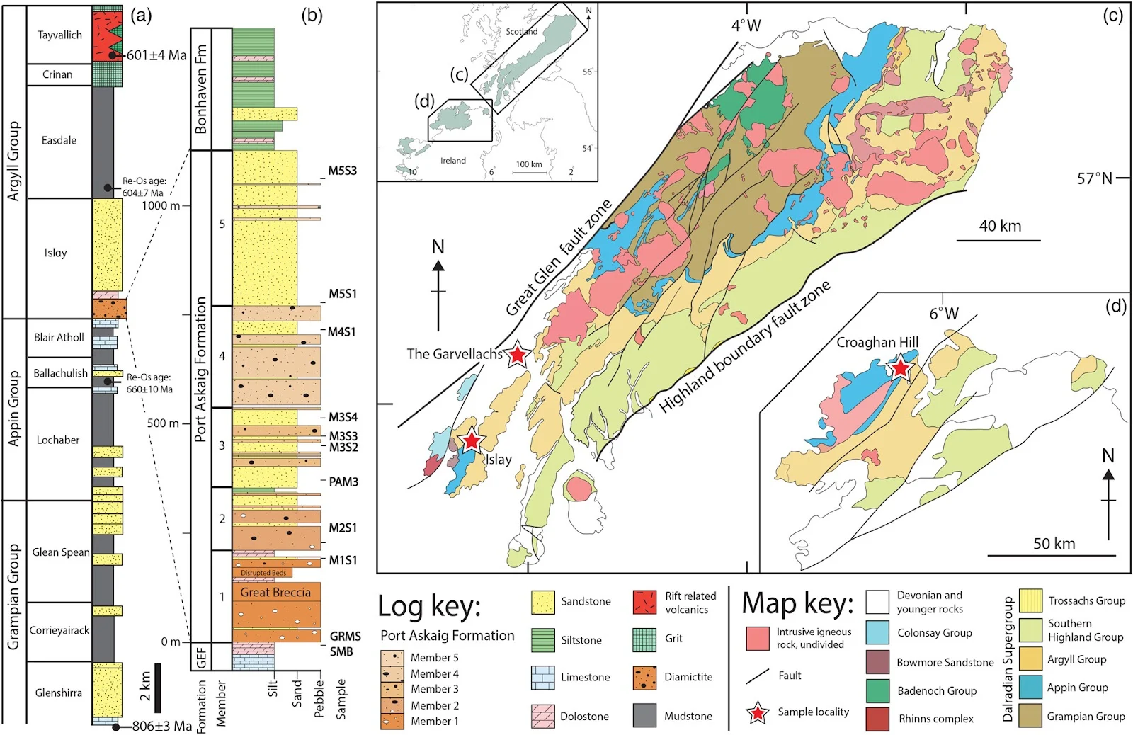 Fig. 1. Synthesis of the geological background of the Port Askaig Formation. (a) Generalized stratigraphy of the lower part of the Dalradian Supergroup (Stephenson et al. 2013.1). The older geochronological constraint shown on the lithostratigraphic log of the Dalradian is derived from a U–Pb age from deformed rocks beneath the Grampian Group (Noble et al. 1996) and the young constraint is from a U–Pb zircon age from rift-related volcanics at the top of the Argyll Group (Dempster et al. 2002.1). Two Re–Os ages are also shown for the Appin Group Ballachulish Slate Formation (Rooney et al. 2011) and Easdale Group Ben Eagach Schist Formation (Moles and Selby 2023.2). The validity of these being depositional ages is discussed in the text. (b) A stratigraphic column from the Port Askaig Formation (Ali et al. 2018). The approximate stratigraphic positions of the sampled horizons are shown. (c) Simplified geological map of the Dalradian Supergroup in Scotland (Shetland Isles not shown). (d) Simplified geological map of the Dalradian Supergroup in Donegal, Ireland. Source: parts (c) and (d) modified after Thomas et al. (2004).
The Port Askaig Formation
The glaciogenic Port Askaig Formation marks the base of the Argyll Group and sits stratigraphically near the middle of the Dalradian Supergroup (Fig. 1). The most complete and best exposed outcrops of the Port Askaig Formation can be found on the Garvellach archipelago and the Isle of Islay in the Argyll region of Scotland, as well in parts of north and south Donegal in Ireland (Fig. 1). Throughout the Dalradian, the thickness of the Port Askaig Formation varies strongly. At its thickest on Islay and the Garvellach Islands it measures c. 1.1 km in total (Ali et al. 2018), however, it thins extensively to the NE and SW of this region. The unusually expanded thickness of the Port Askaig Formation in the SW of Scotland implies that it was deposited in a unique depocentre at that time.
The Port Askaig Formation consists of a total of 48 metadiamictite beds (henceforth referred to as diamictite), as well as sandstones, minor siltstones and dolostone interbeds. The formation is divided into five members, termed Members 1–5 (Kilburn et al. 1965; Spencer 1971), and records 28 glacial episodes, 25 periglacial episodes and 23 non-glacial episodes (Ali et al. 2018). Sedimentological evidence for a glaciated environment begins just below the Port Askaig Formation, in the upper part of the Garbh Eileach Formation (Fairchild et al. 2018.2). The Garbh Eileach Formation is a c. 70 m thick carbonate succession that is apparently unique to the Garvellach Islands, where it shares a demonstrably conformable contact with the Port Askaig Formation (Fairchild et al. 2018.2). By contrast, on Islay, the Port Askaig Formation rests unconformably on the Lossit Limestone, which is argued to be of Tonian age due to the presence of ‘molar-tooth’ calcite microspar (Fairchild et al. 2018.2), a carbonate fabric that is scarce to absent in post-Tonian strata (Shields 2002.2). The upper boundary of the Port Askaig Formation is marked by the mixed carbonate–siliciclastic Bonahaven Formation, which lacks the characteristics of a typical cap carbonate sequence (McCay et al. 2006). Evidence for the termination of glaciation is therefore difficult to pin-point within the Port Askaig Formation. Members 4 and 5 have the fewest interpreted glacial episodes and glaciation had waned dramatically by Member 5, which is composed of rare thin diamictite horizons within thick non-glacial sandstones (Fig. 1; Ali et al. 2018).
The diamictites of the Port Askaig Formation show evidence for both grounded ice and glaciomarine environments, whereas the sandstones are almost all non-glacial and interpreted as deltaic and shallow marine tidal deposits with variable textural and bedform characteristics that relate to minor changes in water depth (Spencer 1971; Eyles 1988; Ali et al. 2018). Sandstone makes up c. 35–40% of the Port Askaig Formation and is present in every member of the succession, evidencing the frequent advance and retreat of ice throughout deposition of the formation (Ali et al. 2018).
The lack of direct age constraints for large parts of the Dalradian means that the Port Askaig Formation has been correlated with both the older ‘Sturtian’ (Prave 1999; Prave et al. 2009.1; Ali et al. 2018; Fairchild et al. 2018.2) and younger ‘Marinoan’ glaciations (Rooney et al. 2011; Stephenson et al. 2013.1; Moles and Selby 2023.2). Support for a ‘Marinoan’ age (c. 645–635 Ma) assignment comes predominantly from Re–Os ages (Rooney et al. 2011; Moles and Selby 2023.2). A Re–Os age of 659.6 ± 9.6 Ma was derived from the Ballachulish Slate Formation, which lies stratigraphically below the Port Askaig Formation in the Appin Group (Rooney et al. 2011) and a Re–Os age of 604.0 ± 7.2 Ma was derived from diagenetic pyrite in the Ben Eagach Schist Formation in the middle part of the Argyll Group (Moles and Selby 2023.2). Within this framework, the Port Askaig Formation could only correlate with the global ‘Marinoan’ glaciation. However, the behaviour of the Re–Os system in metamorphosed sediments is unclear, with Rooney et al. (2014) stating that these age constraints require additional supporting evidence. Furthermore, the uncertainty on the Re–Os age of the Ben Eagach Schist Formation overlaps with the age of the overlying Tayvallich Volcanic Formation (Fig. 1), leaving open the possibility that it may be a diagenetic rather than a depositional age.
Evidence for correlating the Port Askaig Formation with the global ‘Sturtian’ glaciation is centred on combined litho- and chemo-stratigraphic evidence. For example, the strontium and carbon isotope compositions of the Garbh Eileach Formation match the isotope composition of the late Tonian ocean worldwide (Prave et al. 2009.1; Sawaki et al. 2010; Fairchild et al. 2018.2). This is supported by the discovery of the ‘molar-tooth’ calcite in the Lossit Limestone that constrains these strata to the pre-Cryogenian (Fairchild et al. 2018.2). Furthermore, the presence of iron formations within the Port Askaig Formation (Spencer 1971) is thought to be exclusive to rocks of ‘Sturtian’ age (Macdonald et al. 2010.1). The Dalradian in Ireland is also host to glaciogenic deposits younger than the Port Askaig Formation, which, when calibrated against the global carbon and strontium isotope curves, suggests that the Port Askaig Formation represents the earlier ‘Sturtian’ phase of the Cryogenian (McCay et al. 2006). Although the balance of evidence would appear to favour a ‘Sturtian’ assignment for the Port Askaig Formation, there is still no consensus (e.g. Moles and Selby 2023.2).
Rugen Elias J.; Pastore Guido; Vermeesch Pieter; Spencer Anthony M.; Webster David; Smith Adam G. G.; Carter Andrew; Shields Graham A.
Glacially influenced provenance and Sturtian affinity revealed by detrital zircon U–Pb ages from sandstones in the Port Askaig Formation, Dalradian Supergroup Journal of the Geological Society 181(5) jgs2024-029 DOI: 10.1144/jgs2024-029
Copyright: © 2024 The authors.
Published by The Geological Society of London. Open access.
Reprinted under a Creative Commons Attribution 4.0 International license (CC BY 4.0)

It also shows how a global event like the Sturtian Glaciation 700 million years ago left an indelible record in the rock formations, so the complete lack of any evidence of creationism's only global post-'Creation Week' event - their favourite genocidal flood - is even more telling. An event and sudden mass killing on that scale could not have avoided leaving tell-tale evidence in the form of a global layer of detritus forming a distinct boundary layer in every rock formation, yet there is none, de nada, zilch. Not even a hint of it to be found anywhere on Earth.
And to make matters worse for creationists the dating of these rock formations was done using the tried and tested, highly accurate U-Pb dating of zircons of volcanic origin.
And then there is the little problem for creationists of explaining how the strata in the title picture above came to have the 'bubble' shape if it was deposited in a single flood event, like their mythology claims.
What Makes You So Special? From The Big Bang To You

Ten Reasons To Lose Faith: And Why You Are Better Off Without It


No comments :
Post a Comment
Obscene, threatening or obnoxious messages, preaching, abuse and spam will be removed, as will anything by known Internet trolls and stalkers, by known sock-puppet accounts and anything not connected with the post,
A claim made without evidence can be dismissed without evidence. Remember: your opinion is not an established fact unless corroborated.