This cave on Borneo has been used for 20,000 years – and we’ve now dated rock art showing colonial resistance 400 years ago
According to creationists, about 8-10,000 years ago a god made of nothing made everything in the Universe out of nothing using nothing more than magic words. It also created humans and all the other animals a few days later. Then, in a fit of anger because its creation hadn't turned out the way it had designed it, it killed almost all of it in a genocidal flood, reducing the human population of Earth to just 8 related people.
While all that was happening, there were people using a large cave in Sarawak on the island of Borneo, in Malaysia from 35-43,000 years before Earth existed and up until and including European colonisation about 400 years ago. These people left a record of their existence and cultural history in the form of drawings on the cave wall. There is no record of a genocidal flood, and nothing about a god creating other people about 10,000 years ago.
But, according to creationists, just a few thousand years ago the island of Borneo was repopulated by people from the Middle East, who, although all descended from 8 related individuals of Middle Eastern origin, mysteriously adopted the same artistic style as the antediluvian population, forgot all about the genocidal flood and the god who caused it, invented their own gods and continued as though nothing unusual had happened.
That is the sort of mental gymnastics a creationist needs to perform to avoid the dreadful prospect of wondering if they could be wrong.
First, a little about the caves in Sarawak and the art and artifacts found in them:
Cave Art and Artifacts in SarawakIn a paper published yesterday (23 Aug 2023) in PLOS ONE, a team of five palaeoarchaeologists from three Australian universities explain how they dated the cave paintings in Gua Sireh and showed that they recorded territorial violence in the early 1800. They have written about the research in an article in The Conversation which is reprinted here under a Creative Commons licence, reformatted for stylistic consistency:
Sarawak, located on the island of Borneo in Malaysia, is known for its numerous limestone caves that have provided a wealth of archaeological and cultural insights into the region's prehistoric past. These caves have been found to contain various types of art and artifacts created by the indigenous peoples of the area. Some of the most significant caves in Sarawak known for their art and artifacts include:The art found in these caves typically includes paintings, drawings, handprints, and carvings that reflect the cultural and symbolic aspects of the prehistoric societies that inhabited the region. These depictions offer glimpses into the beliefs, activities, and aesthetics of these ancient communities. Researchers and archaeologists continue to study these caves to gain a deeper understanding of the history and evolution of the indigenous peoples of Sarawak.
- Niah Caves: The Niah Caves are among the most famous archaeological sites in Sarawak. They have yielded evidence of human habitation dating back tens of thousands of years. The Great Cave within the Niah Caves complex contains paintings, carvings, and other art that provide insights into the lives and beliefs of prehistoric inhabitants.
- Gua Tambun, Bungoh, and Lintang in Bau: These caves contain ancient rock art, including paintings and drawings on cave walls. The art typically features motifs like human figures, animals, and geometric patterns. These sites have provided valuable information about the artistic and cultural expressions of the region's past inhabitants.
- Gua Tunggu, Gua Longhouse, and Gua Jeriji Saléh in the Baram District: These caves have been found to contain various artifacts such as pottery, beads, and tools, dating back to different periods of human history. These artifacts offer insights into the technological advancements and daily lives of ancient communities.
- Gua Kain Hitam: This cave is known for its unique black handprints that adorn the walls. These handprints are believed to have been created by blowing pigment over hands placed on the cave walls, leaving behind a negative impression. The purpose and significance of these handprints are still debated among researchers.
- Gua Rusa and Gua Madai: These caves have yielded archaeological remains, including pottery fragments, beads, and stone tools. These artifacts help researchers understand the subsistence strategies, trade networks, and social structures of the past inhabitants.
- Gua Pintu: This cave features intricate rock art that includes depictions of animals, humans, and geometric designs. The art is believed to have been created using red ochre and charcoal.
It's important to note that archaeological research is an ongoing process, and new discoveries are made regularly. For the latest and most accurate information about the art and artifacts found in caves in Sarawak, I recommend consulting recent archaeological publications, reports, and news articles.
ChatGPT3.5 " tell me about the art and artifacts found in caves in Sarawak" [Response to user request]
Retrieved from https://chat.openai.com/
Age and Dating Methods.
The art found in the caves of Sarawak varies in age, ranging from thousands to tens of thousands of years old. The dating of this art is typically accomplished through a combination of archaeological techniques, which provide insights into the approximate time periods during which the art was created. Some of the methods used to date the art and artifacts include:It's important to note that dating prehistoric art can be challenging, as these methods have limitations and uncertainties. However, by using a combination of techniques and cross-referencing multiple sources of evidence, researchers can develop a reasonably accurate understanding of the age of the art found in the caves of Sarawak. As archaeological methods and technologies continue to advance, our understanding of the age and context of this art may become more refined.
- Radiocarbon Dating: This is one of the most common methods for dating organic materials, such as charcoal, wood, and bone. Radiocarbon dating relies on measuring the decay of radioactive carbon isotopes in the material. By comparing the ratio of radioactive carbon to stable carbon, scientists can estimate the age of the sample. This method is often used to date charcoal pigments and other organic materials associated with the art.
- Luminescence Dating: Luminescence dating includes techniques like thermoluminescence (TL) and optically stimulated luminescence (OSL). These methods measure the accumulation of trapped electrons in minerals like quartz and feldspar. When these minerals are exposed to sunlight or heat, the trapped electrons are released, and the emitted light can be measured to estimate the time since the last exposure. Luminescence dating is used for dating sediments and materials that were exposed to sunlight or heat during their history.
- Stratigraphy: Archaeologists often use stratigraphy to establish a chronological sequence of layers in a site. By studying the layers of sediment and artifacts, they can infer the relative ages of different archaeological materials. Art found in deeper layers is typically older than art found in more shallow layers.
- Stylistic Analysis: In some cases, art can be dated based on its stylistic characteristics. Over time, artistic styles and techniques change, and researchers can compare the art in question to known styles from other dated contexts. While this method is less precise than scientific dating methods, it can provide general timeframes for the creation of the art.
- Associated Artifacts: Sometimes, the art is found alongside other artifacts, such as pottery, tools, or organic materials, that can be directly dated using methods like radiocarbon dating. The dates of these associated artifacts can help establish a timeframe for the creation of the art.
ChatGPT3.5 "How old is this art and how was it dated?" [Response to user request]
Retrieved from https://chat.openai.com/
Carbon-14 Dating.
Carbon-14 dating, also known as radiocarbon dating, is a widely used method for determining the age of organic materials containing carbon. It relies on the fact that carbon-14, a radioactive isotope of carbon, is present in all living organisms and decays at a predictable rate over time. Here's how carbon-14 dating works and some measures taken to ensure the reliability of the results: How Carbon-14 Dating Works:
- Formation of Carbon-14: Carbon-14 is formed in the upper atmosphere when cosmic rays interact with nitrogen atoms. These cosmic rays convert nitrogen-14 into carbon-14 by adding a neutron to the nucleus, resulting in the formation of carbon-14 and a hydrogen atom.
- Incorporation into Organisms: Living organisms take in carbon dioxide from the atmosphere, including carbon-14 along with the more common carbon-12 and carbon-13 isotopes. This carbon becomes part of their bodies.
- Decay of Carbon-14: Once an organism dies, it no longer takes in carbon from the atmosphere. The carbon-14 in its tissues begins to decay at a known rate, transforming into nitrogen-14 through beta decay. The half-life of carbon-14 is approximately 5,730 years, which means that after this time, half of the initial amount of carbon-14 will have decayed.
- Measuring Carbon-14 Ratio: By comparing the ratio of carbon-14 to carbon-12 in a sample to the ratio in the atmosphere (which has remained relatively constant), scientists can estimate the time that has elapsed since the death of the organism. This is done through various methods such as accelerator mass spectrometry (AMS) or liquid scintillation counting.
Ensuring Reliability:Carbon-14 dating has been extensively refined and tested, and when applied correctly and with consideration of potential sources of error, it can provide reliable age estimates for organic materials spanning back several tens of thousands of years.
- Sample Selection: The sample selected for carbon-14 dating should be well-preserved organic material. Contamination from modern carbon sources, like handling, soil, or groundwater, can affect the accuracy of the results.
- Background Correction: Modern sources of carbon can introduce "background" carbon-14 that can complicate the dating process. To account for this, the ratio of carbon-14 to carbon-12 in the sample is compared to the expected ratio based on the age of the sample. This correction helps eliminate modern contamination.
- Calibration: The half-life of carbon-14 is known, but the carbon-14 levels in the atmosphere have varied slightly over time due to factors like solar activity. Calibration curves are created using samples of known age, such as tree rings, to adjust for these variations and improve the accuracy of dates.
- Multiple Measurements: Often, multiple samples from the same context are dated to ensure consistency and accuracy. If the results from different samples are in agreement, it adds confidence to the estimated age.
- Control Samples: Control samples, which are known to be of a certain age, are regularly included in the dating process to validate the accuracy of the laboratory's equipment and procedures.
- Cross-Checking with Other Methods: When possible, researchers cross-check radiocarbon dates with other dating methods to ensure the accuracy of the results.
ChatGPT3.5 "How does Carbon 14 dating work and what measures are used to ensure the result is reliable?" [Response to user request]
Retrieved from https://chat.openai.com/

This cave on Borneo has been used for 20,000 years – and we’ve now dated rock art showing colonial resistance 400 years ago
Andrea Jalandoni, CC BY-ND
Jillian Huntley, Griffith University; Andrea Jalandoni, Griffith University; Emilie Dotte-Sarout, The University of Western Australia; Fiona Petchey, University of Waikato, and Paul S.C.Taçon, Griffith University
The islands of South-East Asia record a long and dynamic human history of technological innovation, migration and conflict.
The region’s rock art stretches back more than 45,000 years. It’s a unique source of information about this complex human past.
But rock art doesn’t just record ancient history. Researchers have identified artwork documenting the more recent past, including Indigenous resistance to colonial occupation, violent frontier conflicts and enslavement.
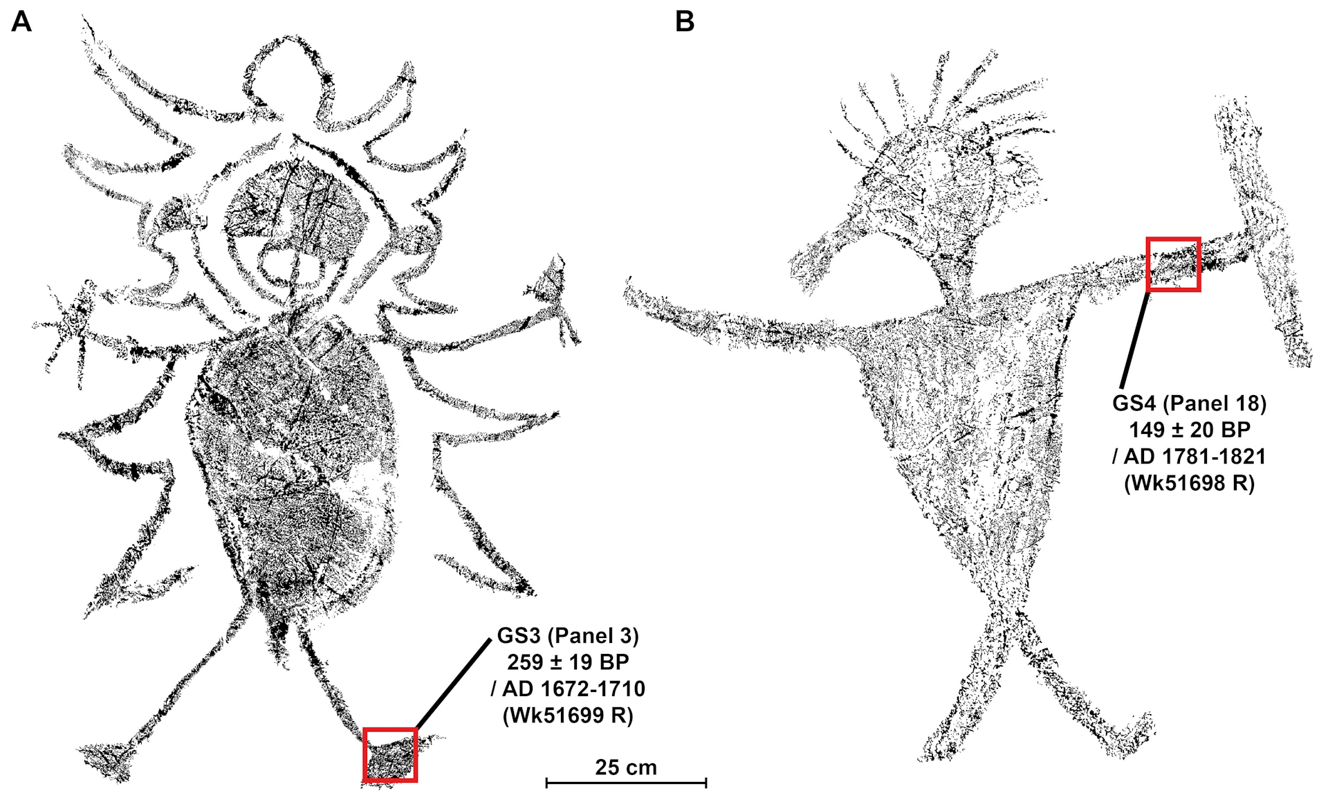
Our new study, published today, shines a new light on rock art of Sarawak (a state of Malaysia on the island of Borneo). The rock art we have dated records resistance to colonial forces in Malaysian Borneo during the 17th to 19th centuries.

The two rock art drawings that were dated and interpreted by our new research.
Digital tracing and design by Lucas Huntley., CC BY-ND
Rock art in Borneo
Black drawings of people, animals, ships and abstract geometric designs dominate caves throughout Borneo’s north-west.
Gua Sireh is one of the region’s best-known rock art sites, attracting hundreds of visitors each year. The cave is about 55 kilometres south-east of Sarawak’s capital, Kuching.
Hundreds of charcoal drawings cover the walls of Gua Sireh. People are shown wearing headdresses. Some are armed with shields, knives and spears in scenes of hunting, butchering, fishing, fighting and dancing.
Malayo-Polynesian Austronesian speakers (whose language originates in Taiwan) spread across Island South-East Asia and the Pacific starting around 3,000 to 4,000 years ago. Austronesian influence at Gua Sireh dates from about 4,000 years ago, indicated by the first appearance of charred rice and pottery.
The presence of Austronesian communities at Gua Sireh is a part of broader evidence for dynamic human migrations in the region over thousands of years.
Further cultural interactions at the site occurred around 2,000 years ago, with grave goods, such as glass beads, showing contact between the Bidayuh and coastal traders.
In the 17th to 19th centuries, there was a period of increasing conflict when Malay elites controlling the region exacted heavy tolls on local Indigenous tribes. Using radiocarbon dating, we have been able to date two large, elaborate human figures to this period. They were drawn between 1670 and 1830.
We interpreted our results informed by the oral histories of the Bidayuh, who have continuing custodial responsibilities over the site today.
Our findings sit alongside other recent archaeological work that has highlighted Indigenous resistance to colonial occupation.
Carbon dating the images
In addition to radiocarbon dating and oral history, another strand of evidence we used to interpret these new dates were the images themselves.
One figure we looked at in our carbon dating brandishes two short-bladed Parang Ilang, the principal weapon used during the warfare that marked the first decades of white rule in Borneo. We have dated this figure as drawn between 1670 and 1710 when Malay elites dominated the Bidayuh.

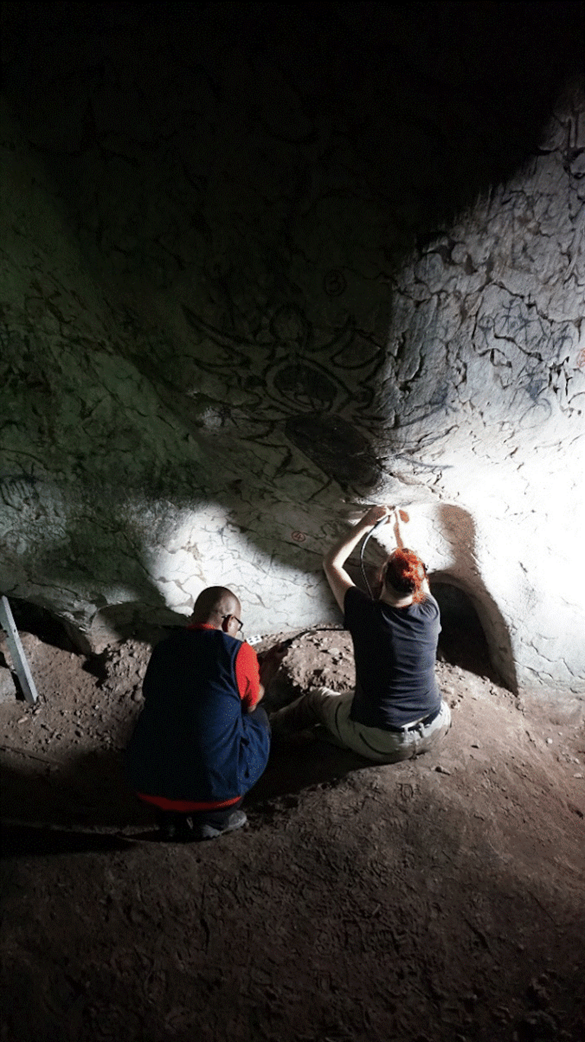
Bidayuh descendant Mohammad Sherman Sauffi William (Sarawak Museum Department) and Jillian Huntley harvesting a sample from the rock art.
Paul S.C. Taçon, CC BY-ND
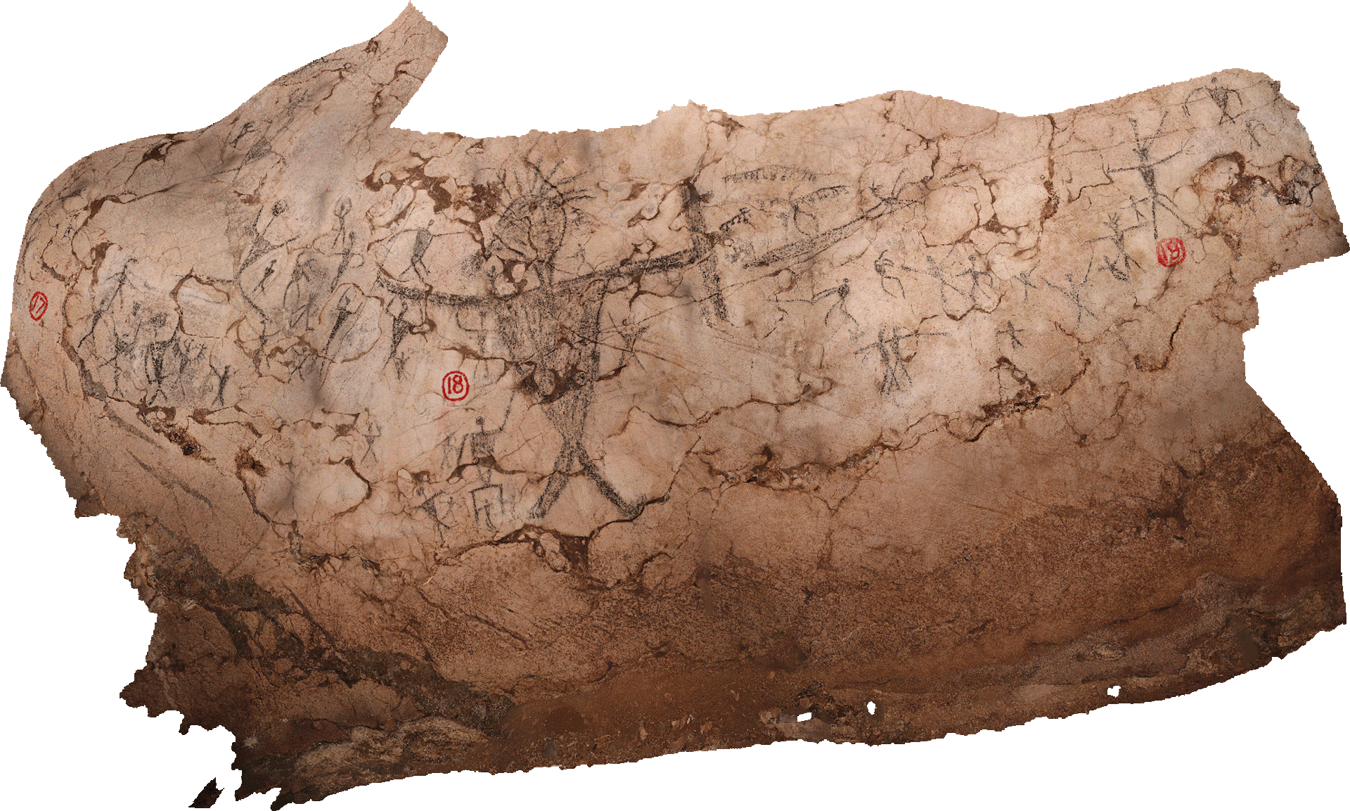
We have dated this figure to between 1790 and 1830. This was a period of increasing conflict between the Bidayuh and Iban (Indigenous peoples from the coast, also known as Sea Dayaks) and Brunei Malay rulers.

The Pandat in this rock art was used exclusively for fighting and protection, suggesting the drawing relates to conflict.
Andrea Jalandoni, CC BY-ND
Brunei rulers were known to not only bully and enslave people but also allowed expeditions of Ibans to attack the Bidayuh. The Ibans were said to keep the heads of the people they slaughtered and handed over the “slaves” they captured to the Brunei authority.
An example from Bidayuh oral histories of the cave being used as a refuge during territorial violence comes from 1855. The British diplomat Spenser St John was shown a skeleton in Gua Sireh. A local tribesman said he had shot this man years earlier, before the rule of James Brooke, which began in 1839.
The shooting resulted from a skirmish with a very harsh Malay chief who had demanded the Bidayuh hand over their children. They refused and retreated to Gua Sireh where they held off a force of 300 armed men.
Suffering some losses (two Bidayuh were shot, and seven were taken prisoner and enslaved), most of the tribe escaped through the far side of the cave complex, saving their children.
Oral histories combined with the figures holding weapons of warfare contextualise the ages we now have for the rock art.

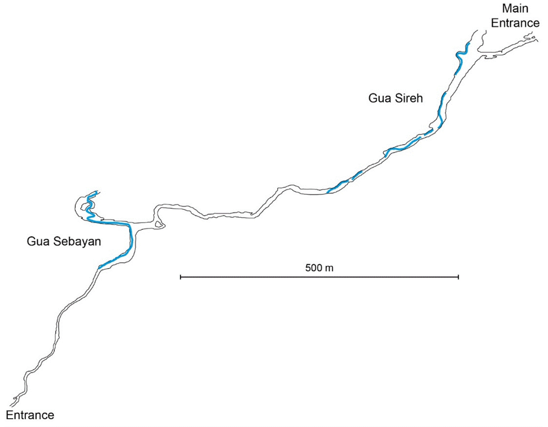
Plan of the Gua Sireh cave system showing passage through Gunung Nambi (limestone hill) via the connecting passage between Gua Sireh and Gua Sebayan. Blue indicates water.
The ubiquity of black drawings across the region and their probable links to the migrations of Austronesian and Malay peoples opens exciting possibilities for further understanding the complexities of rock art production in Island South-East Asia.
This article was coauthored with Mohammad Sherman Sauffi William from the Sarawak Museum Department.
Jillian Huntley, Senior Research Fellow, Centre for Social and Cultural Research, Griffith University; Andrea Jalandoni, Senior Research Fellow, Centre for Social Cultural Research, Griffith University; Emilie Dotte-Sarout, ARC DECRA Research Fellow in Archaeology, The University of Western Australia; Fiona Petchey, Associate Professor and Director, Radiocarbon Dating Laboratory, Te Aka Mātuatua - School of Science, University of Waikato, and Paul S.C.Taçon, Chair in Rock Art Research and Director of the Place, Evolution and Rock Art Heritage Unit (PERAHU), Griffith University
This article is republished from The Conversation under a Creative Commons license. Read the original article.
AbstractNo doubt this evidence of uninterrupted human occupation from tens of thousands of years before creationist superstitions say Earth and humans were created, through when creationists superstition says there was a global genocidal flood in which the human population of Earth was reduced to 8 related Middle Easterners, will be dismissed with the usual wave of the hands by creationists.
Gua Sireh, located in western Sarawak (Malaysian Borneo), is known for its rock art. The cave houses hundreds of charcoal drawings depicting people, often with headdresses, knives and other accoutrements. Here, we present direct radiocarbon dates and pigment characterizations from charcoal drawings of two large (>75 cm), unique Gua Sireh human figures (anthropomorphs). To our knowledge, these are the first chronometric ages generated for Malaysian rock art, providing insights into the social contexts of art production, as well as the opportunities and challenges of dating rock art associated with the Malay/Austronesian diasporas in Southeast Asia more generally. Previous archaeological excavations revealed that people occupied Gua Sireh from around 20,000 years ago to as recently as AD 1900. The site is within Bidayuh territory, and these local Indigenous peoples recall the cave’s use as a refuge during territorial violence in the early 1800s. The age of the drawings, dated between 280 and 120 cal BP (AD 1670 to 1830), corresponds with a period of increasing conflict when the Malay elites controlling the region exacted heavy tolls on the local hill tribes. We discuss rock art production at Gua Sireh in this context of frontier conflict and Bidayuh resistance.
Huntley J, Taçon PSC, Jalandoni A, Petchey F, Dotte-Sarout E, William MSS (2023)
Rock art and frontier conflict in Southeast Asia: Insights from direct radiocarbon ages for the large human figures of Gua Sireh, Sarawak.
PLoS ONE 18(8): e0288902. https://doi.org/10.1371/journal.pone.0288902
Copyright: © 2023 The authors.
Published by PLoS. Open access.
Reprinted under a Creative Commons Attribution 4.0 International license (CC BY 4.0)
 Fig 2. Location of Gua Sireh (Latitude 1° 10.9’ N and Longitude 110° 27.7’ E) relative to the city of Kuching (coordinates after Datan 1993) on the island of Borneo (inset).
 Fig 3. Gua Sireh main chamber entrance and outlook.A) The entrance to Gua Sireh looking south (red arrow) ∼60 meters above the valley floor.B) outlook from the cave entrance northeast down to the valleyPhotographs taken by Paul S.C. Taçon.
No doubt too, they'll dismiss it on the traditional grounds that the scientists are lying; the scientists got the dates wrong, or C14 dating gives false results because the radioactive decay rate has increased (or decreased) over the last 50,000 years (when C14 is used) - unless it supports creationism.
Oh! And the Universe is so finely tuned for life that changing any of the parameters just a little would make life impossible.


No comments :
Post a Comment
Obscene, threatening or obnoxious messages, preaching, abuse and spam will be removed, as will anything by known Internet trolls and stalkers, by known sock-puppet accounts and anything not connected with the post,
A claim made without evidence can be dismissed without evidence. Remember: your opinion is not an established fact unless corroborated.